
Spenden
Rüste dich für dein nächstes Abenteuer:
Als Amazon-Partner verdient diese Website an qualifizierten Käufen, ohne zusätzliche Kosten für Sie.
Topografische Karte San Diego County
Klicken Sie auf die Karte, um die Höhe anzuzeigen.
Spenden
Rüste dich für dein nächstes Abenteuer:
Als Amazon-Partner verdient diese Website an qualifizierten Käufen, ohne zusätzliche Kosten für Sie.
San Diego County
San Diego County's topography is marked by its dramatic variety, ranging from coastal plains to mountainous regions. The county stretches along California's southern border, with a coastline that includes sandy beaches, cliffs, and bays, such as the iconic San Diego Bay. Inland, the terrain rises into the Peninsular Ranges, which include rugged hills and steep mountain slopes, peaking at over 6,000 feet in areas like Pine Valley and Laguna Mountains. These mountains form a backdrop to a series of valleys, canyons, and mesas, such as in the regions around Escondido and Fallbrook. Additionally, the area is known for its desert-like terrain in places such as Ocotillo Wells, which are far removed from the coastal and mountain environments. This varied topography contributes to the region’s unique microclimates and diverse ecosystems.
Spenden
Rüste dich für dein nächstes Abenteuer:
Als Amazon-Partner verdient diese Website an qualifizierten Käufen, ohne zusätzliche Kosten für Sie.
Über diese Karte
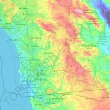
Name: Topografische Karte San Diego County, Höhe, Relief.
Ort: San Diego County, California, United States (32.52952 -117.61054 33.50538 -116.08109)
Durchschnittliche Höhe: 544 m
Minimale Höhe: -71 m
Maximale Höhe: 2.583 m
Spenden
Rüste dich für dein nächstes Abenteuer:
Als Amazon-Partner verdient diese Website an qualifizierten Käufen, ohne zusätzliche Kosten für Sie.
Andere topografische Karten
Klicken Sie auf eine Karte, um ihre Topografie, ihre Höhe und ihr Relief anzuzeigen.
San Francisco Bay Area
United States > California > San Francisco
The San Francisco Bay Area is characterized by a diverse and dynamic topography shaped by geological processes over millions of years. This region features a combination of coastal plains, steep hills, and rugged mountains, all influenced by the tectonic activity associated with the nearby San Andreas Fault…
Durchschnittliche Höhe: 113 m
Santa Cruz Mountains
United States > California > Santa Clara County
The Santa Cruz Mountains are a region of great biological diversity, encompassing cool, moist coastal ecosystems as well as warm, dry chaparral. Much of the area in the Santa Cruz mountains is considered temperate rainforest. In valleys and moist ocean-facing slopes some of the southernmost coast redwoods…
Durchschnittliche Höhe: 230 m
El Dorado Hills
United States > California > El Dorado County > Cameron Park
El Dorado Hills (EDH), as defined by the 2010 census-designated place (CDP), is at the western border of El Dorado County, between the City of Folsom and the unincorporated community of Cameron Park. The northern limits of the CDP are Folsom Lake and the South Fork of the American River, where river rafters…
Durchschnittliche Höhe: 254 m
Spenden
Rüste dich für dein nächstes Abenteuer:
Als Amazon-Partner verdient diese Website an qualifizierten Käufen, ohne zusätzliche Kosten für Sie.
La Jolla Shores Beach
United States > California > San Diego County > San Diego
Durchschnittliche Höhe: 39 m
Silicon Valley
United States > California > Santa Clara County > Palo Alto
Durchschnittliche Höhe: 118 m
Crescent City
United States > California > Del Norte County
The topography of the sea floor surrounding Crescent City has the effect of focusing tsunamis. According to researchers at Humboldt State University and the University of Southern California, the city experienced tsunami conditions 31 times between the years 1933 and 2008. Although many of these incidents were…
Durchschnittliche Höhe: 31 m
Spenden
Rüste dich für dein nächstes Abenteuer:
Als Amazon-Partner verdient diese Website an qualifizierten Käufen, ohne zusätzliche Kosten für Sie.
Half Dome
United States > California > Mariposa County
The Half Dome Cable Route hike runs from the valley floor to the top of the dome in 8.2 mi (13 km) (via the Mist Trail), with 4,800 ft (1,460 m) of elevation gain. The length and difficulty of the trail used to keep it less crowded than other park trails, but in recent years the trail traffic has grown to as…
Durchschnittliche Höhe: 1.887 m
Curry Village
United States > California > Mariposa County
The resort is 1 mile (1.6 km) southeast of Yosemite Village, at an elevation of 4,003 feet (1,220 m), and occupies a central position in the Yosemite Valley. It lies on a talus cone of debris from old rockfalls.
Durchschnittliche Höhe: 1.621 m
Coachella Valley
United States > California > Riverside County > Palm Desert
The area is surrounded on the southwest by the Santa Rosa Mountains, by the San Jacinto Mountains to the west, the Little San Bernardino Mountains to the east and San Gorgonio Mountain to the north. These mountains peak at around 11,000 feet (3,400 m) and tend to average between 5,000 and 7,000 feet (1,500 and…
Durchschnittliche Höhe: 72 m
Spenden
Rüste dich für dein nächstes Abenteuer:
Als Amazon-Partner verdient diese Website an qualifizierten Käufen, ohne zusätzliche Kosten für Sie.
Big Sur
United States > California > Monterey County
The highest peaks of the crest of the coast range are located at an average distance from the coast of three and a half miles [5.6 km]. In this distance they rise to elevations of from three thousand six hundred to five thousand feet [1,100 to 1,500 m] above the sea-level. From San Carpoforo Creek to…
Durchschnittliche Höhe: 193 m
Mount San Antonio
United States > California > Los Angeles County
The prehistoric Hog Back landslide lies in the canyon of San Antonio Creek at 4000' elevation. When the slide occurred, it dammed the river, whose depth built up until the water was released catastrophically, forming a slot canyon which now holds some of the area's few good rock climbing routes (difficulty…
Durchschnittliche Höhe: 2.675 m
Spenden
Rüste dich für dein nächstes Abenteuer:
Als Amazon-Partner verdient diese Website an qualifizierten Käufen, ohne zusätzliche Kosten für Sie.
Pebble Beach
United States > California > Monterey County > Del Monte Forest
Durchschnittliche Höhe: 53 m
Spenden
Rüste dich für dein nächstes Abenteuer:
Als Amazon-Partner verdient diese Website an qualifizierten Käufen, ohne zusätzliche Kosten für Sie.
Mount Umunhum
United States > California > Santa Clara County
The mountain is also the site of the Bay Area NEXRAD weather radar. The high elevation is necessary for line of sight in the region's varied terrain, but it also limits the ability to detect storms with bases lower in the atmosphere.
Durchschnittliche Höhe: 770 m
Yosemite Valley
United States > California > Mariposa County > Yosemite Village
Durchschnittliche Höhe: 2.016 m
Twain Harte
United States > California > Tuolumne County
Twain Harte is situated in Tuolumne County along Highway 108 at an elevation of 3,640 feet (1,110 m).
Durchschnittliche Höhe: 1.123 m
Running Springs
United States > California > San Bernardino County > Running Springs
Running Springs is a mountain community in the San Bernardino Mountains. It is an inholding in the San Bernardino National Forest. Situated at the junction of State Route 18 and State Route 330, it is a major gateway to the mountain communities of Lake Arrowhead, Arrowbear, Green Valley Lake, and Big Bear and…
Durchschnittliche Höhe: 1.656 m
Spenden
Rüste dich für dein nächstes Abenteuer:
Als Amazon-Partner verdient diese Website an qualifizierten Käufen, ohne zusätzliche Kosten für Sie.
Lassen Peak
United States > California > Shasta County
Lassen Peak (/ˈlæsən/ LASS-ən), commonly referred to as Mount Lassen, is a 10,457 ft (3,187 m) lava dome volcano in Lassen Volcanic National Park in Northern California. Located in the Shasta Cascade region above the northern Sacramento Valley, it is the southernmost active volcano in the Cascade Range of…
Durchschnittliche Höhe: 2.689 m
Spenden
Rüste dich für dein nächstes Abenteuer:
Als Amazon-Partner verdient diese Website an qualifizierten Käufen, ohne zusätzliche Kosten für Sie.
Salton Sea
United States > California > Imperial County
The Gulf of California would extend as far north as the city of Indio, were it not for the delta created by the Colorado River. Over three million years, through all of the Pleistocene, the river's delta expanded until it cut off the northern part of the gulf. Since then, the Colorado River has alternated…
Durchschnittliche Höhe: 9 m
Crowley Lake
United States > California > Mono County
Crowley Lake is a census-designated place in Mono County, California. Crowley Lake sits at an elevation of 6,939 feet (2,115 m). The 2020 United States census reported Crowley Lake's population was 980.
Durchschnittliche Höhe: 2.251 m
Spenden
Rüste dich für dein nächstes Abenteuer:
Als Amazon-Partner verdient diese Website an qualifizierten Käufen, ohne zusätzliche Kosten für Sie.
McKinleyville
United States > California > Humboldt County
McKinleyville (formerly Minorsville) is a census-designated place (CDP) in Humboldt County, California McKinleyville is located 5.25 miles (8.4 km) north of Arcata, at an elevation of 141 feet (43 m). The population was 15,177 at the 2010 census, up from 13,599 at the time of the 2000 census.
Durchschnittliche Höhe: 49 m
Spenden
Rüste dich für dein nächstes Abenteuer:
Als Amazon-Partner verdient diese Website an qualifizierten Käufen, ohne zusätzliche Kosten für Sie.
Spenden
Rüste dich für dein nächstes Abenteuer:
Als Amazon-Partner verdient diese Website an qualifizierten Käufen, ohne zusätzliche Kosten für Sie.
Mount Shasta
United States > California > Siskiyou County
Mount Shasta (Shasta: Waka-nunee-Tuki-wuki; Karuk: Úytaahkoo) is a potentially active volcano at the southern end of the Cascade Range in Siskiyou County, California. At an elevation of 14,179 feet (4,321.8 meters), it is the second-highest peak in the Cascades and the fifth-highest in the state. Mount Shasta…
Durchschnittliche Höhe: 3.717 m
Carmichael
United States > California > Sacramento County > Citrus Heights
Durchschnittliche Höhe: 35 m
Spenden
Rüste dich für dein nächstes Abenteuer:
Als Amazon-Partner verdient diese Website an qualifizierten Käufen, ohne zusätzliche Kosten für Sie.
Diamond Springs
United States > California > El Dorado County
Diamond Springs (formerly, Diamond Spring and Diamond) is a census-designated place (CDP) in El Dorado County, California, United States. It is part of the Sacramento–Arden-Arcade–Roseville Metropolitan Statistical Area. The population was 11,037 at the 2010 census, up from 4,888 at the 2000 census. The…
Durchschnittliche Höhe: 542 m
Spenden
Rüste dich für dein nächstes Abenteuer:
Als Amazon-Partner verdient diese Website an qualifizierten Käufen, ohne zusätzliche Kosten für Sie.
Hilmar
United States > California > Merced County
Hilmar is an unincorporated community in Merced County, California, United States. It is located 4.25 miles (6.8 km) west-southwest of Delhi, spanning 3.9 sq mi (10 km2) and at an elevation of 92 ft (28 m) above sea level. For census purposes, Hilmar is aggregated with a nearby community into the Hilmar-Irwin…
Durchschnittliche Höhe: 30 m
Markleeville
United States > California > Alpine County
Markleeville hosts an annual bicycle ride called the Death Ride - Tour of the California Alps. The route goes over five passes for a total distance of 129 miles and over 15,000 feet of elevation gain. In 2010 3,500 riders participated and 2,417 completed the full course of 5 mountain passes.
Durchschnittliche Höhe: 1.788 m
Spenden
Rüste dich für dein nächstes Abenteuer:
Als Amazon-Partner verdient diese Website an qualifizierten Käufen, ohne zusätzliche Kosten für Sie.
Bodie
United States > California > Mono County
Bodie (/ˈboʊdiː/ BOH-dee) is a ghost town in the Bodie Hills east of the Sierra Nevada mountain range in Mono County, California, United States. It is about 75 miles (121 km) southeast of Lake Tahoe, and 12 mi (19 km) east-southeast of Bridgeport, at an elevation of 8,379 feet (2554 m). Bodie became a boom…
Durchschnittliche Höhe: 2.627 m
Harbor Pines
United States > California > Los Angeles County > Los Angeles
Durchschnittliche Höhe: 45 m
Spenden
Rüste dich für dein nächstes Abenteuer:
Als Amazon-Partner verdient diese Website an qualifizierten Käufen, ohne zusätzliche Kosten für Sie.
Spenden
Rüste dich für dein nächstes Abenteuer:
Als Amazon-Partner verdient diese Website an qualifizierten Käufen, ohne zusätzliche Kosten für Sie.
Spenden
Rüste dich für dein nächstes Abenteuer:
Als Amazon-Partner verdient diese Website an qualifizierten Käufen, ohne zusätzliche Kosten für Sie.
Contra Costa Centre
United States > California > Contra Costa County
Contra Costa Centre is an unincorporated community and census-designated place in Contra Costa County, California. Contra Costa Centre sits at an elevation of 92 feet (28 m). The 2010 United States census reported Contra Costa Centre's population was 5,364, while the 2020 census figure was 6,808. Contra Costa…
Durchschnittliche Höhe: 36 m
Spenden
Rüste dich für dein nächstes Abenteuer:
Als Amazon-Partner verdient diese Website an qualifizierten Käufen, ohne zusätzliche Kosten für Sie.
Dorrington
United States > California > Calaveras County
According to the United States Census Bureau, the CDP has a total area of 3.7 square miles (9.6 km2), 99.86% of it land. The elevation is 4,800 feet ASL.
Durchschnittliche Höhe: 1.464 m
Spenden
Rüste dich für dein nächstes Abenteuer:
Als Amazon-Partner verdient diese Website an qualifizierten Käufen, ohne zusätzliche Kosten für Sie.
Spenden
Rüste dich für dein nächstes Abenteuer:
Als Amazon-Partner verdient diese Website an qualifizierten Käufen, ohne zusätzliche Kosten für Sie.
Spenden
Rüste dich für dein nächstes Abenteuer:
Als Amazon-Partner verdient diese Website an qualifizierten Käufen, ohne zusätzliche Kosten für Sie.
Shaver Lake
United States > California > Fresno County > Shaver Lake
Shaver Lake (formerly, Musick Creek and Musick Creek Heights) is a census-designated place (CDP) in Fresno County, California, United States. The population was 634 at the 2010 census, down from 705 at the 2000 census. Shaver Lake is on the southwest end of the lake of the same name, 10 miles (16 km) east of…
Durchschnittliche Höhe: 1.437 m
Spenden
Rüste dich für dein nächstes Abenteuer:
Als Amazon-Partner verdient diese Website an qualifizierten Käufen, ohne zusätzliche Kosten für Sie.
Spenden
Rüste dich für dein nächstes Abenteuer:
Als Amazon-Partner verdient diese Website an qualifizierten Käufen, ohne zusätzliche Kosten für Sie.
Mount Whitney
United States > California > Tulare County
Mount Whitney (Paiute: Tumanguya; Too-man-i-goo-yah) is the highest mountain in the contiguous United States and the Sierra Nevada, with an elevation of 14,505 feet (4,421 m). It is in East–Central California, on the boundary between California's Inyo and Tulare counties, 84.6 miles (136.2 km) west-northwest…
Durchschnittliche Höhe: 3.903 m
Spenden
Rüste dich für dein nächstes Abenteuer:
Als Amazon-Partner verdient diese Website an qualifizierten Käufen, ohne zusätzliche Kosten für Sie.
Spenden
Rüste dich für dein nächstes Abenteuer:
Als Amazon-Partner verdient diese Website an qualifizierten Käufen, ohne zusätzliche Kosten für Sie.
Coyote
United States > California > Santa Clara County
Due to the moderating influence of the Pacific Ocean, Coyote enjoys a mild, Mediterranean climate. Temperatures range from an average midsummer maximum of 32.3°C (90.2°F) to an average midwinter low of 0.9 °C (33.6 °F). Average annual precipitation is 480 mm (18.9 in), and the summer months are typically…
Durchschnittliche Höhe: 131 m
Golden Gate Park
United States > California > San Francisco
In the 1860s, San Franciscans began to feel the need for a spacious public park similar to Central Park, which was then taking shape in New York City. Golden Gate Park was carved out of unpromising sand and shore dunes that were known as the Outside Lands, in an unincorporated area west of San Francisco's…
Durchschnittliche Höhe: 71 m
Cedar Glen
United States > California > San Bernardino County > Lake Arrowhead
Durchschnittliche Höhe: 1.640 m
Fort Irwin
United States > California > San Bernardino County
Fort Irwin National Training Center (Fort Irwin NTC) is a major training area for the United States military in the Mojave Desert in northern San Bernardino County, California. Fort Irwin is at an average elevation of 2,454 feet (748 m). It is located 37 miles (60 km) northeast of Barstow, in the Calico…
Durchschnittliche Höhe: 774 m
Spenden
Rüste dich für dein nächstes Abenteuer:
Als Amazon-Partner verdient diese Website an qualifizierten Käufen, ohne zusätzliche Kosten für Sie.