
Topografische Karte Baja California
Interaktive Karte
Klicken Sie auf die Karte, um die Höhe anzuzeigen.
Über diese Karte
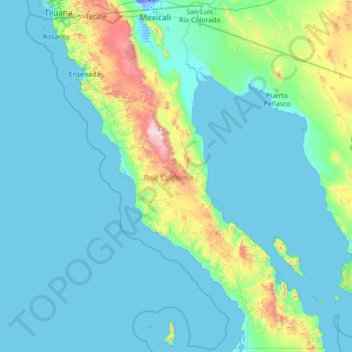
Name: Topografische Karte Baja California, Höhe, Relief.
Ort: Baja California, Mexico (27.99999 -118.36506 32.71867 -112.75267)
Durchschnittliche Höhe: 179 m
Minimale Höhe: -11 m
Maximale Höhe: 2.850 m
Baja California is the 12th-largest state by area in Mexico. Its geography ranges from beaches to forests and deserts. The backbone of the state is the Sierra de Baja California, where Picacho del Diablo, the highest point of the peninsula, is located. This mountain range effectively divides the weather patterns in the state. In the northwest, the weather is semi-dry and Mediterranean. In the narrow center, the weather changes to be more humid due to altitude. It is in this area where a few valleys can be found, such as the Valle de Guadalupe, the major wine-producing area in Mexico. To the east of the mountain range, the Sonoran Desert dominates the landscape. In the south, the weather becomes drier and gives way to the Vizcaíno Desert. The state is also home to numerous islands off both of its shores. Baja California is also home to Guadalupe Island, the westernmost point of Mexico. The Coronado Islands, Todos Santos islands, and Cedros Island are also on the Pacific shore. On the Gulf of California, the largest island is Angel de la Guarda Island, separated from the peninsula by the deep and narrow Canal de Ballenas.
Andere topografische Karten
Klicken Sie auf eine Karte, um ihre Topografie, ihre Höhe und ihr Relief anzuzeigen.
Lázaro Cárdenas
Mexico > State of Mexico > Naucalpan de Juárez
Lázaro Cárdenas, Naucalpan de Juárez, State of Mexico, 53569, Mexico
Durchschnittliche Höhe: 2.282 m
San Miguel de Allende
Mexico > Guanajuato > San Miguel de Allende
San Miguel de Allende, Guanajuato, Mexico
Durchschnittliche Höhe: 1.964 m
Bosques de las Lomas
Mexico > State of Mexico > Ciudad Satélite
Bosques de las Lomas, Miguel Hidalgo, Ciudad Satélite, Mexico City, State of Mexico, 11910, Mexico
Durchschnittliche Höhe: 2.414 m
Tlajomulco de Zúñiga
Tlajomulco de Zúñiga, Región Centro, Jalisco, Mexico
Durchschnittliche Höhe: 1.670 m
Cancún
Mexico > Quintana Roo > Benito Juárez
Cancún, Benito Juárez, Quintana Roo, Mexico
Durchschnittliche Höhe: 5 m
Cabo San Lucas
Mexico > Baja California Sur > Los Cabos Municipality
Cabo San Lucas, Los Cabos Municipality, Baja California Sur, 23470, Mexico
Durchschnittliche Höhe: 94 m
San Antonio la Isla
San Antonio la Isla, State of Mexico, Mexico
Durchschnittliche Höhe: 2.585 m
Querétaro
Mexico > Querétaro > Municipio de Querétaro
Querétaro, Municipio de Querétaro, Querétaro, Mexico
Durchschnittliche Höhe: 1.921 m
San Cristóbal
Mexico > Chiapas > San Cristóbal de las Casas
San Cristóbal, San Cristóbal de las Casas, Chiapas, 29200, Mexico
Durchschnittliche Höhe: 2.038 m
Cedros Island
Mexico > Baja California > Municipio de Ensenada
Cedros Island, Municipio de Ensenada, Baja California, 22990, Mexico
Durchschnittliche Höhe: 67 m
Interlomas
Interlomas, Huixquilucan, 52760, Mexico
Durchschnittliche Höhe: 2.656 m
Yucatán Peninsula
Mexico > Quintana Roo > Othón P. Blanco
Yucatán Peninsula, Othón P. Blanco, Quintana Roo, Mexico
Durchschnittliche Höhe: 100 m
Tepeji del Río de Ocampo
Tepeji del Río de Ocampo, Hidalgo, Mexico
Durchschnittliche Höhe: 2.296 m
Malinche
Mexico > Tlaxcala > Teolocholco
Malinche, Teolocholco, Tlaxcala, Mexico
Durchschnittliche Höhe: 3.911 m
San Juan Colorado
Mexico > Oaxaca > San Juan Colorado
San Juan Colorado, Oaxaca, 71750, Mexico
Durchschnittliche Höhe: 412 m
San Miguel
Mexico > Nuevo León > García
San Miguel, García, Nuevo León, Mexico
Durchschnittliche Höhe: 1.431 m
Jesús del Monte
Jesús del Monte, Morelia, Michoacán, 58350, Mexico
Durchschnittliche Höhe: 2.136 m
Guadalajara
Mexico > Jalisco > Guadalajara
Guadalajara, Jalisco, 44360, Mexico
Durchschnittliche Höhe: 1.572 m
Casas Grandes
Mexico > Chihuahua > Casas Grandes
Casas Grandes, Chihuahua, 31850, Mexico
Durchschnittliche Höhe: 1.503 m
Sierra Negra
Mexico > Puebla > Chalchicomula de Sesma
Sierra Negra, Chalchicomula de Sesma, Puebla, Mexico
Durchschnittliche Höhe: 4.099 m
Llano Hermoso
Mexico > Durango > Nuevo Ideal
Llano Hermoso, Nuevo Ideal, Durango, Mexico
Durchschnittliche Höhe: 1.967 m
Isla Cozumel
Mexico > Quintana Roo > Cozumel
Isla Cozumel, Cozumel, Quintana Roo, Mexico
Durchschnittliche Höhe: 2 m
Río Blanco
Río Blanco, Zapopan, Región Centro, Jalisco, 45158, Mexico
Durchschnittliche Höhe: 1.575 m
Puerto Vallarta
Mexico > Jalisco > Puerto Vallarta
Puerto Vallarta, Región Costa Norte, Jalisco, 48300, Mexico
Durchschnittliche Höhe: 306 m
Ventanilla
Mexico > Oaxaca > Santa María Colotepec
Ventanilla, Santa María Colotepec, Oaxaca, 70937, Mexico
Durchschnittliche Höhe: 79 m
Santa María Colotepec
Santa María Colotepec, Oaxaca, Mexico
Durchschnittliche Höhe: 179 m
Tijuana
Mexico > Baja California > Municipio de Tijuana
Tijuana, Municipio de Tijuana, Baja California, 22320, Mexico
Durchschnittliche Höhe: 141 m
Santa Cruz Cuautomatitla
Mexico > Puebla > Tochimilco
Santa Cruz Cuautomatitla, Tochimilco, Puebla, Mexico
Durchschnittliche Höhe: 2.492 m
San Clemente de Terapa
San Clemente de Terapa, Moctezuma, Sonora, Mexico
Durchschnittliche Höhe: 618 m