
Topografische Karte Lerma
Interaktive Karte
Klicken Sie auf die Karte, um die Höhe anzuzeigen.
Über diese Karte
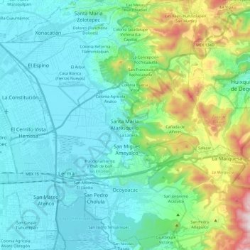
Name: Topografische Karte Lerma, Höhe, Relief.
Ort: Lerma, State of Mexico, Mexico (19.22195 -99.57198 19.43067 -99.38191)
Durchschnittliche Höhe: 2.788 m
Minimale Höhe: 2.556 m
Maximale Höhe: 3.681 m
The municipality's territory is irregular with rolling hills leading up to the Sierra de Las Cruces mountain range, which extend from north to south on the east side of the municipality. In this range, there are a number of steep valleys, such as Salazar. Most of the residents are found in the foothills of the Sierra. The western part used to be occupied by the Lerma Lake, a marsh connected with the Lerma River. This river is the main surface water source although there are some other streams and fresh-water springs. Most of the municipality's potable water is provided by 38 deep wells. The climate is temperate and fairly moist. The warmest months are May and June with most rains occurring from June to October. Average high temperatures are around 19C.. Lows average about 7C but freezing temperatures in winter are not uncommon. The higher elevations are covered in forests of fir and pine. In the center of the municipality there are grass areas and willow, eucalyptus and other trees. Wildlife consists mostly of small mammals and reptiles. The soils and rocks here are volcanic in origin, with the west dominated by old lake and marshbeds.
Andere topografische Karten
Klicken Sie auf eine Karte, um ihre Topografie, ihre Höhe und ihr Relief anzuzeigen.
San Antonio la Isla
San Antonio la Isla, State of Mexico, Mexico
Durchschnittliche Höhe: 2.585 m
Naucalpan de Juárez
Naucalpan de Juárez, State of Mexico, Mexico
Durchschnittliche Höhe: 2.366 m
Tlalnepantla de Baz
Tlalnepantla de Baz, State of Mexico, Mexico
Durchschnittliche Höhe: 2.323 m
San Martín de las Pirámides
San Martín de las Pirámides, State of Mexico, 55850, Mexico
Durchschnittliche Höhe: 2.396 m
Huitznahuac
Mexico > State of Mexico > Chiautla
Huitznahuac, Chiautla, State of Mexico, 52270, Mexico
Durchschnittliche Höhe: 2.253 m
Isidro Fabela
Isidro Fabela, State of Mexico, Mexico
Durchschnittliche Höhe: 3.073 m
La Colmena
Mexico > State of Mexico > Tlalnepantla de Baz > Tlalnepantla
La Colmena, Tlalnepantla, Tlalnepantla de Baz, State of Mexico, 54190, Mexico
Durchschnittliche Höhe: 2.454 m
Atizapán de Zaragoza
Mexico > State of Mexico > Atizapán de Zaragoza
Atizapán de Zaragoza, State of Mexico, 52990, Mexico
Durchschnittliche Höhe: 2.424 m
Temascalcingo
Temascalcingo, State of Mexico, 50414, Mexico
Durchschnittliche Höhe: 2.603 m
Eje Neovolcánico
Mexico > State of Mexico > Amecameca
Eje Neovolcánico, Amecameca, State of Mexico, Mexico
Durchschnittliche Höhe: 4.179 m
Jilotzingo
Jilotzingo, State of Mexico, Mexico
Durchschnittliche Höhe: 2.968 m
Chicoloapan
Chicoloapan, State of Mexico, Mexico
Durchschnittliche Höhe: 2.326 m
Nezahualcóyotl
Nezahualcóyotl, State of Mexico, Mexico
Durchschnittliche Höhe: 2.235 m
Tepexpan
Tepexpan, Acolman, State of Mexico, 55885, Mexico
Durchschnittliche Höhe: 2.266 m
San Franciso de Asís
San Franciso de Asís, State of Mexico, Mexico
Durchschnittliche Höhe: 890 m
Teotihuacán
Teotihuacán, State of Mexico, Mexico
Durchschnittliche Höhe: 2.346 m
Cuautitlán Izcalli
Mexico > State of Mexico > Cuautitlán Izcalli
Cuautitlán Izcalli, State of Mexico, 54700, Mexico
Durchschnittliche Höhe: 2.357 m
Rio San Juan
Mexico > State of Mexico > Teotihuacán > Teotihuacán
Rio San Juan, Teotihuacán, State of Mexico, 55845, Mexico
Durchschnittliche Höhe: 2.261 m
Santiago Tianguistenco
Mexico > State of Mexico > Tianguistenco
Santiago Tianguistenco, Tianguistenco, State of Mexico, 52600, Mexico
Durchschnittliche Höhe: 2.645 m
Popocatépetl
Mexico > State of Mexico > Atlautla
Popocatépetl, Atlautla, State of Mexico, Mexico
Durchschnittliche Höhe: 4.810 m
Santa Ana Jilotzingo
Mexico > State of Mexico > Jilotzingo > Santa Ana Jilotzingo
Santa Ana Jilotzingo, Jilotzingo, State of Mexico, 54490, Mexico
Durchschnittliche Höhe: 2.760 m
Chapa de Mota
Mexico > State of Mexico > Chapa de Mota
Chapa de Mota, State of Mexico, 54350, Mexico
Durchschnittliche Höhe: 2.636 m
Ciudad Adolfo Lopez Mateos
Mexico > State of Mexico > Atizapán de Zaragoza > Ciudad Adolfo Lopez Mateos
Ciudad Adolfo Lopez Mateos, Atizapán de Zaragoza, State of Mexico, 52940, Mexico
Durchschnittliche Höhe: 2.426 m
Quinta Coty
Mexico > State of Mexico > Chalco > Rancho Santa María Atoyac
Quinta Coty, Benito Juárez, Rancho Santa María Atoyac, Chalco, State of Mexico, 56680, Mexico
Durchschnittliche Höhe: 2.262 m
San Franscisco
Mexico > State of Mexico > San Franscisco
San Franscisco, State of Mexico, 52680, Mexico
Durchschnittliche Höhe: 2.829 m
Atizapán de Zaragoza
Mexico > State of Mexico > Atizapán de Zaragoza
Atizapán de Zaragoza, State of Mexico, Mexico
Durchschnittliche Höhe: 2.410 m
Atizapán
Mexico > State of Mexico > Atizapán
Atizapán, State of Mexico, Mexico
Durchschnittliche Höhe: 2.582 m
Valle de Bravo
Valle de Bravo, State of Mexico, Mexico
Durchschnittliche Höhe: 2.072 m
Santa María Ajoloapan
Mexico > State of Mexico > Santa María Ajoloapan
Santa María Ajoloapan, Tecámac, State of Mexico, 55755, Mexico
Durchschnittliche Höhe: 2.286 m
Teotihuacán
Mexico > State of Mexico > Teotihuacán
Teotihuacán, State of Mexico, 55845, Mexico
Durchschnittliche Höhe: 2.311 m
Tonatico
Mexico > State of Mexico > Tonatico
Tonatico, State of Mexico, Mexico
Durchschnittliche Höhe: 1.617 m
Ojo de Agua
Mexico > State of Mexico > Zinacantepec > Ojo de Agua
Ojo de Agua, Zinacantepec, State of Mexico, 51384, Mexico
Durchschnittliche Höhe: 3.051 m
Santa Catarina
Mexico > State of Mexico > Lerma
Santa Catarina, Lerma, State of Mexico, 52055, Mexico
Durchschnittliche Höhe: 2.602 m
San Lorenzo Tlalmimilolpan
Mexico > State of Mexico > Teotihuacán > San Lorenzo Tlalmimilolpan
San Lorenzo Tlalmimilolpan, Teotihuacán, State of Mexico, 55845, Mexico
Durchschnittliche Höhe: 2.274 m
Lerma de Villada
Mexico > State of Mexico > Lerma
Lerma de Villada, Lerma, State of Mexico, 52006, Mexico
Durchschnittliche Höhe: 2.577 m
Buenavista
Mexico > State of Mexico > Tultitlán > Buenavista
Buenavista, Tultitlán, State of Mexico, 54958, Mexico
Durchschnittliche Höhe: 2.336 m
Ecatepec de Morelos
Ecatepec de Morelos, State of Mexico, Mexico
Durchschnittliche Höhe: 2.296 m
La Paz
Mexico > State of Mexico > La Paz
La Paz, State of Mexico, Mexico
Durchschnittliche Höhe: 2.324 m
Naucalpan
Mexico > State of Mexico > Naucalpan de Juárez > Naucalpan
Naucalpan, Naucalpan de Juárez, State of Mexico, 53370, Mexico
Durchschnittliche Höhe: 2.459 m
Santa Maria Rayon
Mexico > State of Mexico > Santa Maria Rayon
Santa Maria Rayon, Rayón, State of Mexico, 52220, Mexico
Durchschnittliche Höhe: 2.617 m
Americas
Americas, State of Mexico, 52145, Mexico
Durchschnittliche Höhe: 2.579 m
Huixquilucan
Huixquilucan, State of Mexico, Mexico
Durchschnittliche Höhe: 2.921 m