
Topografische Karte Acolman
Interaktive Karte
Klicken Sie auf die Karte, um die Höhe anzuzeigen.
Über diese Karte
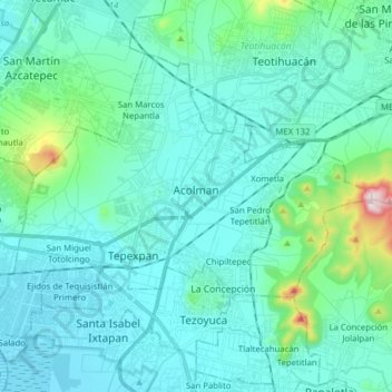
Name: Topografische Karte Acolman, Höhe, Relief.
Ort: Acolman, State of Mexico, Mexico (19.58332 -98.99723 19.69023 -98.84075)
Durchschnittliche Höhe: 2.298 m
Minimale Höhe: 2.230 m
Maximale Höhe: 2.744 m
The municipality is located on a plain in the northern portion of the Valley of Mexico called the Valley of Teotihuacan. It has only three significant elevations. The eastern border is marked by the Sierra de Patlachique and the west is marked by a mountain called Chiconautla. Chiconautla and Tlahuilco are forested and are protected areas. From the mountains that surround this plain flow a number of streams such as the San José and the San Antonio, which are commonly called the Rio Grande and the Rio Chico. The municipality lacks fresh water springs, with most potable water coming from deep wells. The climate is temperate and semi-arid with rains in the summer. Temperatures can range from 36 °C in the summer to -4 °C in the winter. Forested areas of the municipality contain trees such as ahuehuete, mesquite, eucalyptus and Peruvian pepper. In the lower, flatter regions, the flora consists of shrubs, grasses, cactus and other plants adapted to dry areas. Wildlife consists mostly of small mammals such as rabbits and skunks, small reptiles such as the chameleon and insects.
Andere topografische Karten
Klicken Sie auf eine Karte, um ihre Topografie, ihre Höhe und ihr Relief anzuzeigen.
San Antonio la Isla
San Antonio la Isla, State of Mexico, Mexico
Durchschnittliche Höhe: 2.585 m
Naucalpan de Juárez
Naucalpan de Juárez, State of Mexico, Mexico
Durchschnittliche Höhe: 2.366 m
Tlalnepantla de Baz
Tlalnepantla de Baz, State of Mexico, Mexico
Durchschnittliche Höhe: 2.323 m
San Martín de las Pirámides
San Martín de las Pirámides, State of Mexico, 55850, Mexico
Durchschnittliche Höhe: 2.396 m
Huitznahuac
Mexico > State of Mexico > Chiautla
Huitznahuac, Chiautla, State of Mexico, 52270, Mexico
Durchschnittliche Höhe: 2.253 m
Isidro Fabela
Isidro Fabela, State of Mexico, Mexico
Durchschnittliche Höhe: 3.073 m
La Colmena
Mexico > State of Mexico > Tlalnepantla de Baz > Tlalnepantla
La Colmena, Tlalnepantla, Tlalnepantla de Baz, State of Mexico, 54190, Mexico
Durchschnittliche Höhe: 2.454 m
Atizapán de Zaragoza
Mexico > State of Mexico > Atizapán de Zaragoza
Atizapán de Zaragoza, State of Mexico, 52990, Mexico
Durchschnittliche Höhe: 2.424 m
Temascalcingo
Temascalcingo, State of Mexico, 50414, Mexico
Durchschnittliche Höhe: 2.603 m
Eje Neovolcánico
Mexico > State of Mexico > Amecameca
Eje Neovolcánico, Amecameca, State of Mexico, Mexico
Durchschnittliche Höhe: 4.179 m
Jilotzingo
Jilotzingo, State of Mexico, Mexico
Durchschnittliche Höhe: 2.968 m
Chicoloapan
Chicoloapan, State of Mexico, Mexico
Durchschnittliche Höhe: 2.326 m
Nezahualcóyotl
Nezahualcóyotl, State of Mexico, Mexico
Durchschnittliche Höhe: 2.235 m
Tepexpan
Tepexpan, Acolman, State of Mexico, 55885, Mexico
Durchschnittliche Höhe: 2.266 m
San Franciso de Asís
San Franciso de Asís, State of Mexico, Mexico
Durchschnittliche Höhe: 890 m
Teotihuacán
Teotihuacán, State of Mexico, Mexico
Durchschnittliche Höhe: 2.346 m
Cuautitlán Izcalli
Mexico > State of Mexico > Cuautitlán Izcalli
Cuautitlán Izcalli, State of Mexico, 54700, Mexico
Durchschnittliche Höhe: 2.357 m
Rio San Juan
Mexico > State of Mexico > Teotihuacán > Teotihuacán
Rio San Juan, Teotihuacán, State of Mexico, 55845, Mexico
Durchschnittliche Höhe: 2.261 m
Santiago Tianguistenco
Mexico > State of Mexico > Tianguistenco
Santiago Tianguistenco, Tianguistenco, State of Mexico, 52600, Mexico
Durchschnittliche Höhe: 2.645 m
Popocatépetl
Mexico > State of Mexico > Atlautla
Popocatépetl, Atlautla, State of Mexico, Mexico
Durchschnittliche Höhe: 4.810 m
Santa Ana Jilotzingo
Mexico > State of Mexico > Jilotzingo > Santa Ana Jilotzingo
Santa Ana Jilotzingo, Jilotzingo, State of Mexico, 54490, Mexico
Durchschnittliche Höhe: 2.760 m
Chapa de Mota
Mexico > State of Mexico > Chapa de Mota
Chapa de Mota, State of Mexico, 54350, Mexico
Durchschnittliche Höhe: 2.636 m
Ciudad Adolfo Lopez Mateos
Mexico > State of Mexico > Atizapán de Zaragoza > Ciudad Adolfo Lopez Mateos
Ciudad Adolfo Lopez Mateos, Atizapán de Zaragoza, State of Mexico, 52940, Mexico
Durchschnittliche Höhe: 2.426 m
Quinta Coty
Mexico > State of Mexico > Chalco > Rancho Santa María Atoyac
Quinta Coty, Benito Juárez, Rancho Santa María Atoyac, Chalco, State of Mexico, 56680, Mexico
Durchschnittliche Höhe: 2.262 m
San Franscisco
Mexico > State of Mexico > San Franscisco
San Franscisco, State of Mexico, 52680, Mexico
Durchschnittliche Höhe: 2.829 m
Atizapán de Zaragoza
Mexico > State of Mexico > Atizapán de Zaragoza
Atizapán de Zaragoza, State of Mexico, Mexico
Durchschnittliche Höhe: 2.410 m
Atizapán
Mexico > State of Mexico > Atizapán
Atizapán, State of Mexico, Mexico
Durchschnittliche Höhe: 2.582 m
Valle de Bravo
Valle de Bravo, State of Mexico, Mexico
Durchschnittliche Höhe: 2.072 m
Santa María Ajoloapan
Mexico > State of Mexico > Santa María Ajoloapan
Santa María Ajoloapan, Tecámac, State of Mexico, 55755, Mexico
Durchschnittliche Höhe: 2.286 m
Teotihuacán
Mexico > State of Mexico > Teotihuacán
Teotihuacán, State of Mexico, 55845, Mexico
Durchschnittliche Höhe: 2.311 m
Tonatico
Mexico > State of Mexico > Tonatico
Tonatico, State of Mexico, Mexico
Durchschnittliche Höhe: 1.617 m
Ojo de Agua
Mexico > State of Mexico > Zinacantepec > Ojo de Agua
Ojo de Agua, Zinacantepec, State of Mexico, 51384, Mexico
Durchschnittliche Höhe: 3.051 m
Santa Catarina
Mexico > State of Mexico > Lerma
Santa Catarina, Lerma, State of Mexico, 52055, Mexico
Durchschnittliche Höhe: 2.602 m
San Lorenzo Tlalmimilolpan
Mexico > State of Mexico > Teotihuacán > San Lorenzo Tlalmimilolpan
San Lorenzo Tlalmimilolpan, Teotihuacán, State of Mexico, 55845, Mexico
Durchschnittliche Höhe: 2.274 m
Lerma de Villada
Mexico > State of Mexico > Lerma
Lerma de Villada, Lerma, State of Mexico, 52006, Mexico
Durchschnittliche Höhe: 2.577 m
Buenavista
Mexico > State of Mexico > Tultitlán > Buenavista
Buenavista, Tultitlán, State of Mexico, 54958, Mexico
Durchschnittliche Höhe: 2.336 m
Ecatepec de Morelos
Ecatepec de Morelos, State of Mexico, Mexico
Durchschnittliche Höhe: 2.296 m
La Paz
Mexico > State of Mexico > La Paz
La Paz, State of Mexico, Mexico
Durchschnittliche Höhe: 2.324 m
Naucalpan
Mexico > State of Mexico > Naucalpan de Juárez > Naucalpan
Naucalpan, Naucalpan de Juárez, State of Mexico, 53370, Mexico
Durchschnittliche Höhe: 2.459 m
Santa Maria Rayon
Mexico > State of Mexico > Santa Maria Rayon
Santa Maria Rayon, Rayón, State of Mexico, 52220, Mexico
Durchschnittliche Höhe: 2.617 m
Americas
Americas, State of Mexico, 52145, Mexico
Durchschnittliche Höhe: 2.579 m
Huixquilucan
Huixquilucan, State of Mexico, Mexico
Durchschnittliche Höhe: 2.921 m