
Topografische Karte Challis
Interaktive Karte
Klicken Sie auf die Karte, um die Höhe anzuzeigen.
Über diese Karte
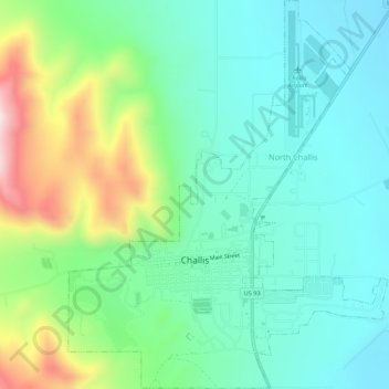
Name: Topografische Karte Challis, Höhe, Relief.
Ort: Challis, Custer County, Idaho, United States (44.49235 -114.24897 44.53080 -114.20465)
Durchschnittliche Höhe: 1.626 m
Minimale Höhe: 1.508 m
Maximale Höhe: 1.932 m
Challis is located at 44°30′15″N 114°13′42″W / 44.50417°N 114.22833°W / 44.50417; -114.22833 (44.504260, -114.228279), at an elevation of 5,253 feet (1,601 m) above sea level.
Andere topografische Karten
Klicken Sie auf eine Karte, um ihre Topografie, ihre Höhe und ihr Relief anzuzeigen.
Stanley Lake
United States > Idaho > Custer County
Stanley Lake, Custer County, Idaho, United States
Durchschnittliche Höhe: 2.075 m
Pine Summit
United States > Idaho > Custer County
Pine Summit, Custer County, Idaho, United States
Durchschnittliche Höhe: 2.315 m
Stanley
United States > Idaho > Custer County
Stanley, Custer County, Idaho, United States
Durchschnittliche Höhe: 1.931 m
Thousand Springs
United States > Idaho > Custer County
Thousand Springs, Custer County, Idaho, United States
Durchschnittliche Höhe: 1.922 m
Borah Peak
United States > Idaho > Custer County
Borah Peak, Custer County, Idaho, United States
Durchschnittliche Höhe: 3.280 m
Lost River
United States > Idaho > Custer County
Lost River, Custer County, Idaho, United States
Durchschnittliche Höhe: 2.198 m
Redfish Lake
United States > Idaho > Custer County
Redfish Lake, Custer County, Idaho, United States
Durchschnittliche Höhe: 2.144 m