
Topografische Karte Redfish Lake
Interaktive Karte
Klicken Sie auf die Karte, um die Höhe anzuzeigen.
Über diese Karte
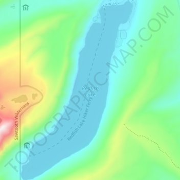
Name: Topografische Karte Redfish Lake, Höhe, Relief.
Ort: Redfish Lake, Custer County, Idaho, United States (44.09323 -114.95587 44.14436 -114.91176)
Durchschnittliche Höhe: 2.144 m
Minimale Höhe: 1.989 m
Maximale Höhe: 2.637 m
The surface elevation of Redfish Lake is 6,547 feet (1,996 m) above sea level. The lake is 4.5 miles (7.2 km) long and 0.72 miles (1.2 km) wide, with a maximum depth of 387 feet (118 m), and 11 miles (18 km) of shoreline. The actual trail around the lake is 17.5 miles (28 km) in length.
Andere topografische Karten
Klicken Sie auf eine Karte, um ihre Topografie, ihre Höhe und ihr Relief anzuzeigen.
Stanley Lake
United States > Idaho > Custer County
Stanley Lake, Custer County, Idaho, United States
Durchschnittliche Höhe: 2.075 m
Pine Summit
United States > Idaho > Custer County
Pine Summit, Custer County, Idaho, United States
Durchschnittliche Höhe: 2.315 m
Stanley
United States > Idaho > Custer County
Stanley, Custer County, Idaho, United States
Durchschnittliche Höhe: 1.931 m
Thousand Springs
United States > Idaho > Custer County
Thousand Springs, Custer County, Idaho, United States
Durchschnittliche Höhe: 1.922 m
Challis
United States > Idaho > Custer County
Challis, Custer County, Idaho, United States
Durchschnittliche Höhe: 1.626 m
Borah Peak
United States > Idaho > Custer County
Borah Peak, Custer County, Idaho, United States
Durchschnittliche Höhe: 3.280 m
Lost River
United States > Idaho > Custer County
Lost River, Custer County, Idaho, United States
Durchschnittliche Höhe: 2.198 m