
Topografische Karte Stanley
Interaktive Karte
Klicken Sie auf die Karte, um die Höhe anzuzeigen.
Über diese Karte
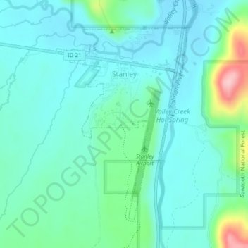
Name: Topografische Karte Stanley, Höhe, Relief.
Ort: Stanley, Custer County, Idaho, United States (44.20026 -114.94822 44.22109 -114.92829)
Durchschnittliche Höhe: 1.931 m
Minimale Höhe: 1.895 m
Maximale Höhe: 2.080 m
Stanley is located at 44°13′0″N 114°56′16″W / 44.21667°N 114.93778°W / 44.21667; -114.93778 (44.216698, -114.937814), at an elevation of 6,253 feet (1,906 m) above sea level
Andere topografische Karten
Klicken Sie auf eine Karte, um ihre Topografie, ihre Höhe und ihr Relief anzuzeigen.
Stanley Lake
United States > Idaho > Custer County
Stanley Lake, Custer County, Idaho, United States
Durchschnittliche Höhe: 2.075 m
Pine Summit
United States > Idaho > Custer County
Pine Summit, Custer County, Idaho, United States
Durchschnittliche Höhe: 2.315 m
Thousand Springs
United States > Idaho > Custer County
Thousand Springs, Custer County, Idaho, United States
Durchschnittliche Höhe: 1.922 m
Challis
United States > Idaho > Custer County
Challis, Custer County, Idaho, United States
Durchschnittliche Höhe: 1.626 m
Borah Peak
United States > Idaho > Custer County
Borah Peak, Custer County, Idaho, United States
Durchschnittliche Höhe: 3.280 m
Lost River
United States > Idaho > Custer County
Lost River, Custer County, Idaho, United States
Durchschnittliche Höhe: 2.198 m
Redfish Lake
United States > Idaho > Custer County
Redfish Lake, Custer County, Idaho, United States
Durchschnittliche Höhe: 2.144 m