
Topografische Karte Clark County
Interaktive Karte
Klicken Sie auf die Karte, um die Höhe anzuzeigen.
Über diese Karte
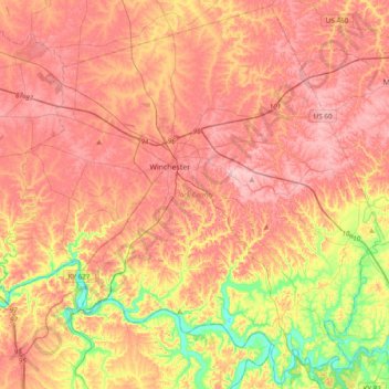
Name: Topografische Karte Clark County, Höhe, Relief.
Ort: Clark County, Kentucky, 40391, United States (37.82181 -84.34897 38.11516 -83.96650)
Durchschnittliche Höhe: 273 m
Minimale Höhe: 171 m
Maximale Höhe: 341 m
According to the United States Census Bureau, the county has a total area of 255 square miles (660 km2), of which 252 square miles (650 km2) is land and 2.7 square miles (7.0 km2) (1.1%) is water. The topography of the county is gently rolling. Tobacco is a major farm crop, and livestock are also raised there. Water sources include the Kentucky River, Red River, Lulbegrud Creek, and Boone's Creek. Lulbegrud Creek is named for Lorbrulgrud, the capital city of Brobdingnag, the land of giant people in Jonathan Swift's Gulliver's Travels.
Andere topografische Karten
Klicken Sie auf eine Karte, um ihre Topografie, ihre Höhe und ihr Relief anzuzeigen.
Lexington
United States > Kentucky > Lexington
Lexington, Fayette County, Kentucky, 40508, United States
Durchschnittliche Höhe: 285 m
East Bernstadt
United States > Kentucky > Laurel County
East Bernstadt, Laurel County, Kentucky, United States
Durchschnittliche Höhe: 367 m
Sandhill
United States > Kentucky > Muhlenberg County
Sandhill, Muhlenberg County, Kentucky, 42369, United States
Durchschnittliche Höhe: 143 m
McDowell
United States > Kentucky > Floyd County
McDowell, Floyd County, Kentucky, 41647, United States
Durchschnittliche Höhe: 324 m
Pike County
Pike County, Kentucky, United States
Durchschnittliche Höhe: 418 m
Indian Hills Cherokee Section
United States > Kentucky > Jefferson County > Indian Hills
Indian Hills Cherokee Section, Indian Hills, Jefferson County, Kentucky, 40207, United States
Durchschnittliche Höhe: 168 m
Morning View
United States > Kentucky > Kenton County
Morning View, Kenton County, Kentucky, 41063, United States
Durchschnittliche Höhe: 192 m
Broad Bottom
United States > Kentucky > Pike County
Broad Bottom, Pike County, Kentucky, 41659, United States
Durchschnittliche Höhe: 274 m
Louisville
United States > Kentucky > Jefferson County > Louisville
Louisville, Jefferson County, Kentucky, 40202-2923, United States
Durchschnittliche Höhe: 180 m
Plumville
United States > Kentucky > Mason County
Plumville, Mason County, Kentucky, United States
Durchschnittliche Höhe: 247 m
Lawrence County
Lawrence County, Kentucky, United States
Durchschnittliche Höhe: 255 m
Carrollton
United States > Kentucky > Carroll County
Carrollton, Carroll County, Kentucky, United States
Durchschnittliche Höhe: 170 m
Livingston County
Livingston County, Kentucky, United States
Durchschnittliche Höhe: 131 m
Keaton
United States > Kentucky > Johnson County
Keaton, Johnson County, Kentucky, 41226, United States
Durchschnittliche Höhe: 270 m
Owensboro
United States > Kentucky > Daviess County
Owensboro, Daviess County, Kentucky, United States
Durchschnittliche Höhe: 123 m
Aboretum
United States > Kentucky > Calloway County > Murray
Aboretum, Murray, Calloway County, Kentucky, United States
Durchschnittliche Höhe: 168 m
Edsel
United States > Kentucky > Elliott County
Edsel, Elliott County, Kentucky, United States
Durchschnittliche Höhe: 277 m
Dunmor
United States > Kentucky > Muhlenberg County
Dunmor, Muhlenberg County, Kentucky, 42339, United States
Durchschnittliche Höhe: 179 m
Villa Hills
United States > Kentucky > Kenton County
Villa Hills, Kenton County, Kentucky, United States
Durchschnittliche Höhe: 224 m
Oak Grove
United States > Kentucky > Christian County
Oak Grove, Christian County, Kentucky, 42262, United States
Durchschnittliche Höhe: 170 m
Muhlenberg County
Muhlenberg County, Kentucky, United States
Durchschnittliche Höhe: 144 m
Burtonville
United States > Kentucky > Lewis County
Burtonville, Lewis County, Kentucky, United States
Durchschnittliche Höhe: 254 m
Buster Hill
United States > Kentucky > Wayne County > Monticello
Buster Hill, Monticello, Wayne County, Kentucky, 42633, United States
Durchschnittliche Höhe: 295 m
Limp
United States > Kentucky > Hardin County
Limp, Hardin County, Kentucky, United States
Durchschnittliche Höhe: 211 m
Danville
United States > Kentucky > Boyle County
Danville, Boyle County, Kentucky, United States
Durchschnittliche Höhe: 290 m
Elizabethtown
United States > Kentucky > Hardin County
Elizabethtown, Hardin County, Kentucky, 42701, United States
Durchschnittliche Höhe: 241 m
Union County
Union County, Kentucky, United States
Durchschnittliche Höhe: 122 m
Hindman
United States > Kentucky > Knott County
Hindman, Knott County, Kentucky, United States
Durchschnittliche Höhe: 388 m
Fulton County
Fulton County, Kentucky, United States
Durchschnittliche Höhe: 109 m
E.P. "Tom" Sawyer State Park
United States > Kentucky > Jefferson County > Louisville > Lakeland
E.P. "Tom" Sawyer State Park, Lakeland, Louisville, Jefferson County, Kentucky, United States
Durchschnittliche Höhe: 209 m
Lebanon Junction
United States > Kentucky > Bullitt County
Lebanon Junction, Bullitt County, Kentucky, United States
Durchschnittliche Höhe: 144 m
Gilbertsville
United States > Kentucky > Marshall County
Gilbertsville, Marshall County, Kentucky, United States
Durchschnittliche Höhe: 104 m
Nelson County
Nelson County, Kentucky, United States
Durchschnittliche Höhe: 207 m
Morehead
United States > Kentucky > Rowan County
Morehead, Rowan County, Kentucky, 40351, United States
Durchschnittliche Höhe: 287 m
McConnell Springs
United States > Kentucky > Fayette County > Lexington
McConnell Springs, Lexington, Fayette County, Kentucky, United States
Durchschnittliche Höhe: 287 m
Guthrie
United States > Kentucky > Todd County
Guthrie, Todd County, Kentucky, United States
Durchschnittliche Höhe: 172 m
Maysville
United States > Kentucky > Mason County
Maysville, Mason County, Kentucky, 41056, United States
Durchschnittliche Höhe: 236 m
Wilmore
United States > Kentucky > Jessamine County
Wilmore, Jessamine County, Kentucky, 40390, United States
Durchschnittliche Höhe: 272 m
Dry Ridge
United States > Kentucky > Grant County
Dry Ridge, Grant County, Kentucky, United States
Durchschnittliche Höhe: 274 m
Epperson
United States > Kentucky > McCracken County
Epperson, McCracken County, Kentucky, United States
Durchschnittliche Höhe: 107 m
Hampton Manor
United States > Kentucky > Clark County > Winchester
Hampton Manor, Winchester, Clark County, Kentucky, 40391, United States
Durchschnittliche Höhe: 297 m
Nicholasville
United States > Kentucky > Jessamine County
Nicholasville, Jessamine County, Kentucky, 40356, United States
Durchschnittliche Höhe: 285 m
Eolia
United States > Kentucky > Letcher County
Eolia, Letcher County, Kentucky, 40826, United States
Durchschnittliche Höhe: 612 m
William Whitley State Historic House
United States > Kentucky > Lincoln County
William Whitley State Historic House, Lincoln County, Kentucky, United States
Durchschnittliche Höhe: 284 m
Crestwood
United States > Kentucky > Oldham County
Crestwood, Oldham County, Kentucky, United States
Durchschnittliche Höhe: 223 m
West Point
United States > Kentucky > Hardin County
West Point, Hardin County, Kentucky, United States
Durchschnittliche Höhe: 163 m
Kenton County
Kenton County, Kentucky, United States
Durchschnittliche Höhe: 233 m
Taylor Mill
United States > Kentucky > Kenton County
Taylor Mill, Kenton County, Kentucky, 41015, United States
Durchschnittliche Höhe: 211 m
Shakertown
United States > Kentucky > Mercer County
Shakertown, Mercer County, Kentucky, United States
Durchschnittliche Höhe: 252 m
Weeksbury
United States > Kentucky > Floyd County
Weeksbury, Floyd County, Kentucky, 41669, United States
Durchschnittliche Höhe: 487 m