
Spenden
Rüste dich für dein nächstes Abenteuer:
Als Amazon-Partner verdient diese Website an qualifizierten Käufen, ohne zusätzliche Kosten für Sie.
Topografische Karte Fishlake National Forest
Klicken Sie auf die Karte, um die Höhe anzuzeigen.
Spenden
Rüste dich für dein nächstes Abenteuer:
Als Amazon-Partner verdient diese Website an qualifizierten Käufen, ohne zusätzliche Kosten für Sie.
Über diese Karte
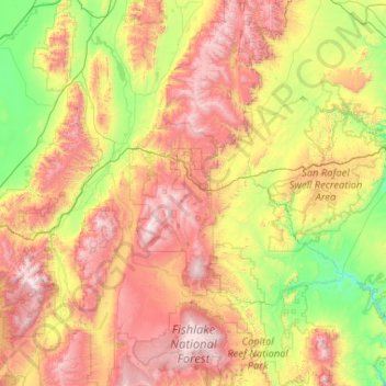
Name: Topografische Karte Fishlake National Forest, Höhe, Relief.
Ort: Fishlake National Forest, Utah, United States (37.92985 -112.63586 39.55395 -111.18704)
Durchschnittliche Höhe: 2.080 m
Minimale Höhe: 1.273 m
Maximale Höhe: 3.660 m
Spenden
Rüste dich für dein nächstes Abenteuer:
Als Amazon-Partner verdient diese Website an qualifizierten Käufen, ohne zusätzliche Kosten für Sie.
Andere topografische Karten
Klicken Sie auf eine Karte, um ihre Topografie, ihre Höhe und ihr Relief anzuzeigen.
Salt Lake City
United States > Utah > Salt Lake County > Salt Lake City
Salt Lake City has an area of 110.4 square miles (286 km2) and an average elevation of 4,327 feet (1,319 m) above sea level. The lowest point within the boundaries of the city is 4,210 feet (1,280 m) near the Jordan River and the Great Salt Lake, and the highest is Grandview Peak, at 9,410 feet (2,868 m).
Durchschnittliche Höhe: 1.625 m
Spenden
Rüste dich für dein nächstes Abenteuer:
Als Amazon-Partner verdient diese Website an qualifizierten Käufen, ohne zusätzliche Kosten für Sie.
Spenden
Rüste dich für dein nächstes Abenteuer:
Als Amazon-Partner verdient diese Website an qualifizierten Käufen, ohne zusätzliche Kosten für Sie.
Spenden
Rüste dich für dein nächstes Abenteuer:
Als Amazon-Partner verdient diese Website an qualifizierten Käufen, ohne zusätzliche Kosten für Sie.
Brady Place
United States > Utah > Salt Lake County > West Valley City
Durchschnittliche Höhe: 1.353 m
Spenden
Rüste dich für dein nächstes Abenteuer:
Als Amazon-Partner verdient diese Website an qualifizierten Käufen, ohne zusätzliche Kosten für Sie.
Grandview Peak
United States > Utah > Salt Lake County > Salt Lake City
Durchschnittliche Höhe: 2.533 m
Spenden
Rüste dich für dein nächstes Abenteuer:
Als Amazon-Partner verdient diese Website an qualifizierten Käufen, ohne zusätzliche Kosten für Sie.
Silver Reef
United States > Utah > Washington County > Leeds
Silver Reef is close to the western border of the Colorado Plateau and about 15 miles (24 km) northeast of St. George and 1 mile (1.6 km) west of Leeds. Dixie National Forest, Leeds Creek, the White Reef, and the Pine Valley Mountain Wilderness lie directly west of Silver Reef. The Pine Valley Mountain…
Durchschnittliche Höhe: 1.185 m
Little Cottonwood Creek Valley
United States > Utah > Salt Lake County > Cottonwood Heights
Durchschnittliche Höhe: 1.437 m
Spenden
Rüste dich für dein nächstes Abenteuer:
Als Amazon-Partner verdient diese Website an qualifizierten Käufen, ohne zusätzliche Kosten für Sie.
Gunlock
United States > Utah > Washington County
The community lies on the Santa Clara River, northwest of the Red Mountains along local roads, northwest of the city of St. George, the county seat of Washington County. Its elevation is 3,658 feet (1,115 m). Although Gunlock is unincorporated, it has a post office, with the ZIP code of 84733.
Durchschnittliche Höhe: 1.210 m
Spenden
Rüste dich für dein nächstes Abenteuer:
Als Amazon-Partner verdient diese Website an qualifizierten Käufen, ohne zusätzliche Kosten für Sie.
Spenden
Rüste dich für dein nächstes Abenteuer:
Als Amazon-Partner verdient diese Website an qualifizierten Käufen, ohne zusätzliche Kosten für Sie.
Spenden
Rüste dich für dein nächstes Abenteuer:
Als Amazon-Partner verdient diese Website an qualifizierten Käufen, ohne zusätzliche Kosten für Sie.
Grouse Creek
United States > Utah > Box Elder County
Grouse Creek (also Cookesville) is an unincorporated community in the nearly unpopulated northwestern region of Box Elder County, Utah, United States, near the Idaho and Nevada borders. The community lies along unpaved roads north of State Route 30 in the Grouse Creek Mountains. Its elevation is 5,331 feet…
Durchschnittliche Höhe: 1.653 m
Spenden
Rüste dich für dein nächstes Abenteuer:
Als Amazon-Partner verdient diese Website an qualifizierten Käufen, ohne zusätzliche Kosten für Sie.
Spenden
Rüste dich für dein nächstes Abenteuer:
Als Amazon-Partner verdient diese Website an qualifizierten Käufen, ohne zusätzliche Kosten für Sie.
Freemont Springs Park
United States > Utah > Utah County > Eagle Mountain
Durchschnittliche Höhe: 1.490 m
Spenden
Rüste dich für dein nächstes Abenteuer:
Als Amazon-Partner verdient diese Website an qualifizierten Käufen, ohne zusätzliche Kosten für Sie.
Spenden
Rüste dich für dein nächstes Abenteuer:
Als Amazon-Partner verdient diese Website an qualifizierten Käufen, ohne zusätzliche Kosten für Sie.
Spenden
Rüste dich für dein nächstes Abenteuer:
Als Amazon-Partner verdient diese Website an qualifizierten Käufen, ohne zusätzliche Kosten für Sie.
Spenden
Rüste dich für dein nächstes Abenteuer:
Als Amazon-Partner verdient diese Website an qualifizierten Käufen, ohne zusätzliche Kosten für Sie.
Cedar City
United States > Utah > Iron County > Cedar City > Cedar City
Durchschnittliche Höhe: 2.087 m
Hurricane
United States > Utah > Washington County > Hurricane > Hurricane
Durchschnittliche Höhe: 1.075 m
Kimball Junction
United States > Utah > Summit County > Kimball Junction
Durchschnittliche Höhe: 2.004 m
Spenden
Rüste dich für dein nächstes Abenteuer:
Als Amazon-Partner verdient diese Website an qualifizierten Käufen, ohne zusätzliche Kosten für Sie.
Park City
United States > Utah > Summit County > Park City
In the summertime, many valley residents of the Wasatch Front visit the town to escape high temperatures. Park City is usually cooler than Salt Lake City as it lies mostly higher than 7,000 feet (2,100 m) above sea level, while Salt Lake City is situated at an elevation of about 4,300 feet (1,300 m).
Durchschnittliche Höhe: 2.315 m
Draper
United States > Utah > Salt Lake County > Draper > Draper
Draper's climate is roughly identical to that of other Salt Lake City suburbs. However, due to being further away from the Great Salt Lake, varied elevation, and from the downtown urban heat island effect, Draper experiences a slightly drier winter, and more extremes in temperatures.
Durchschnittliche Höhe: 1.464 m
Spenden
Rüste dich für dein nächstes Abenteuer:
Als Amazon-Partner verdient diese Website an qualifizierten Käufen, ohne zusätzliche Kosten für Sie.
Brigham City
United States > Utah > Box Elder County > Brigham City > Brigham City
Durchschnittliche Höhe: 1.489 m
Parleys Canyon
United States > Utah > Salt Lake County > Millcreek
Parleys Canyon is a canyon located in the U.S. state of Utah. The canyon provides the route of Interstate 80 (I-80) (and previously the Lincoln Highway, U.S. Route 40, and a railroad) up the western slope of the Wasatch Mountains and is a relatively wide, straight canyon other than near its mouth. The mountain…
Durchschnittliche Höhe: 1.577 m
Spenden
Rüste dich für dein nächstes Abenteuer:
Als Amazon-Partner verdient diese Website an qualifizierten Käufen, ohne zusätzliche Kosten für Sie.
Spenden
Rüste dich für dein nächstes Abenteuer:
Als Amazon-Partner verdient diese Website an qualifizierten Käufen, ohne zusätzliche Kosten für Sie.
The Great Salt Lake Shorelands Preserve
United States > Utah > Davis County
Durchschnittliche Höhe: 1.292 m
Spenden
Rüste dich für dein nächstes Abenteuer:
Als Amazon-Partner verdient diese Website an qualifizierten Käufen, ohne zusätzliche Kosten für Sie.
Spenden
Rüste dich für dein nächstes Abenteuer:
Als Amazon-Partner verdient diese Website an qualifizierten Käufen, ohne zusätzliche Kosten für Sie.
Storm Mountain Terrace
United States > Utah > Salt Lake County > Sandy
Durchschnittliche Höhe: 1.392 m
Granite Park
United States > Utah > Salt Lake County > Sandy > Granite Crest
Durchschnittliche Höhe: 1.534 m
Spenden
Rüste dich für dein nächstes Abenteuer:
Als Amazon-Partner verdient diese Website an qualifizierten Käufen, ohne zusätzliche Kosten für Sie.
Spenden
Rüste dich für dein nächstes Abenteuer:
Als Amazon-Partner verdient diese Website an qualifizierten Käufen, ohne zusätzliche Kosten für Sie.
Brighton
United States > Utah > Salt Lake County
Brighton has a high-altitude cold continental climate (Köppen Dsb/Dsc), with dry summers and very snowy winters.
Durchschnittliche Höhe: 2.852 m
Spenden
Rüste dich für dein nächstes Abenteuer:
Als Amazon-Partner verdient diese Website an qualifizierten Käufen, ohne zusätzliche Kosten für Sie.
Spenden
Rüste dich für dein nächstes Abenteuer:
Als Amazon-Partner verdient diese Website an qualifizierten Käufen, ohne zusätzliche Kosten für Sie.