
Topografische Karte Dodge County
Interaktive Karte
Klicken Sie auf die Karte, um die Höhe anzuzeigen.
Über diese Karte
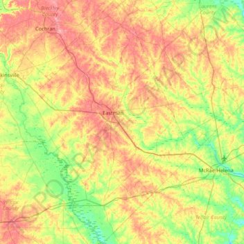
Name: Topografische Karte Dodge County, Höhe, Relief.
Ort: Dodge County, Georgia, United States (31.90071 -83.37412 32.45243 -82.85804)
Durchschnittliche Höhe: 84 m
Minimale Höhe: 40 m
Maximale Höhe: 141 m
The Heart of Georgia Regional Airport is located three miles east of Eastman off of State Route 46. Elevation 304'. Runway 02/20 is 6,506'x100'and has a precision instrument landing system. The airport is owned by the Heart of Georgia Regional Airport Authority and is home to the Middle Georgia State College Georgia Aviation campus. Middle Georgia State College operates the Federal Aviation Administration's #1 ranked student control tower in the United States. Other businesses at the airport include aircraft manufacturing, aircraft metal finishing, and general metal fabrication. The airport's fixed-base operator is located in the terminal building midfield. The terminal building is named after W. S. Stuckey Sr., founder of Stuckey's Candy Company (now Standard Candy) an aviation pioneer who is from Eastman.
Andere topografische Karten
Klicken Sie auf eine Karte, um ihre Topografie, ihre Höhe und ihr Relief anzuzeigen.
Toccoa
United States > Georgia > Stephens County
Toccoa, Stephens County, Georgia, 30577, United States
Durchschnittliche Höhe: 303 m
Chatham County
United States > Georgia > Chatham County
Chatham County, Georgia, United States
Durchschnittliche Höhe: 3 m
Spalding County
Spalding County, Georgia, United States
Durchschnittliche Höhe: 247 m
Bonaire
United States > Georgia > Houston County
Bonaire, Houston County, Georgia, 31005, United States
Durchschnittliche Höhe: 100 m
Helen
United States > Georgia > White County
Helen, White County, Georgia, 30545, United States
Durchschnittliche Höhe: 488 m
Booth Lake
United States > Georgia > Wilkes County > Washington > Ravenwood Park
Booth Lake, Ravenwood Park, Washington, Wilkes County, Georgia, United States
Durchschnittliche Höhe: 175 m
Fort Pulaski
United States > Georgia > Chatham County
Fort Pulaski, Fort Perimeter Trail, Chatham County, Georgia, 31328, United States
Durchschnittliche Höhe: 1 m
Lowndes County
Lowndes County, Georgia, United States
Durchschnittliche Höhe: 52 m
Griffin Lake
United States > Georgia > Brooks County
Griffin Lake, Brooks County, Georgia, United States
Durchschnittliche Höhe: 60 m
Rowland Lake
United States > Georgia > Jones County
Rowland Lake, Jones County, Georgia, United States
Durchschnittliche Höhe: 175 m
Ponder Park
United States > Georgia > Tift County > Omega
Ponder Park, Omega, Tift County, Georgia, United States
Durchschnittliche Höhe: 96 m
Hiawassee
United States > Georgia > Towns County
Hiawassee, Towns County, Georgia, United States
Durchschnittliche Höhe: 620 m
Powder Springs
United States > Georgia > Cobb County
Powder Springs, Cobb County, Georgia, United States
Durchschnittliche Höhe: 291 m
Brasstown Bald
United States > Georgia > Towns County
Brasstown Bald, Towns County, Georgia, United States
Durchschnittliche Höhe: 1.161 m
Toombs County
Toombs County, Georgia, United States
Durchschnittliche Höhe: 57 m
Adel
United States > Georgia > Cook County
Adel, Cook County, Georgia, 31620, United States
Durchschnittliche Höhe: 72 m
Jackson County
Jackson County, Georgia, United States
Durchschnittliche Höhe: 253 m
Cherokee Hills
United States > Georgia > Coffee County
Cherokee Hills, Coffee County, Georgia, United States
Durchschnittliche Höhe: 70 m
Webster County
Webster County, Georgia, United States
Durchschnittliche Höhe: 146 m
Bulloch County
Bulloch County, Georgia, United States
Durchschnittliche Höhe: 48 m
Lake City
United States > Georgia > Clayton County
Lake City, Clayton County, Georgia, United States
Durchschnittliche Höhe: 287 m
Walton County
Walton County, Georgia, United States
Durchschnittliche Höhe: 243 m
Whitfield County
Whitfield County, Georgia, United States
Durchschnittliche Höhe: 258 m
Forbes Lake
United States > Georgia > Macon County
Forbes Lake, Macon County, Georgia, United States
Durchschnittliche Höhe: 126 m
Leesburg
United States > Georgia > Lee County
Leesburg, Lee County, Georgia, United States
Durchschnittliche Höhe: 76 m
Snodgrass Hill
United States > Georgia > Walker County > Fort Oglethorpe
Snodgrass Hill, Fort Oglethorpe, Walker County, Georgia, 30741, United States
Durchschnittliche Höhe: 250 m
Moon River
United States > Georgia > Chatham County > Burnside View
Moon River, Burnside View, Chatham County, Georgia, 31411, United States
Durchschnittliche Höhe: 2 m
Rossville
United States > Georgia > Walker County
Rossville, Walker County, Georgia, United States
Durchschnittliche Höhe: 251 m
Henry County
Henry County, Georgia, United States
Durchschnittliche Höhe: 238 m
Lake Seminole
United States > Georgia > Seminole County > Chattahoochee
Lake Seminole, Chattahoochee, Seminole County, Georgia, United States
Durchschnittliche Höhe: 32 m
Baxley
United States > Georgia > Appling County
Baxley, Appling County, Georgia, 31515, United States
Durchschnittliche Höhe: 61 m
Bainbridge
United States > Georgia > Decatur County
Bainbridge, Decatur County, Georgia, United States
Durchschnittliche Höhe: 37 m
Houston County
Houston County, Georgia, United States
Durchschnittliche Höhe: 111 m
Shenandoah Woods
United States > Georgia > Columbia County
Shenandoah Woods, Columbia County, Georgia, 30907, United States
Durchschnittliche Höhe: 97 m
Hiram
United States > Georgia > Paulding County
Hiram, Paulding County, Georgia, United States
Durchschnittliche Höhe: 306 m
Roswell
United States > Georgia > Fulton County
Roswell, Fulton County, Georgia, United States
Durchschnittliche Höhe: 316 m
Lawrenceville
United States > Georgia > Gwinnett County
Lawrenceville, Gwinnett County, Georgia, United States
Durchschnittliche Höhe: 312 m
Elbert County
Elbert County, Georgia, United States
Durchschnittliche Höhe: 177 m
High Hill Lake
United States > Georgia > Glynn County
High Hill Lake, Glynn County, Georgia, 31525, United States
Durchschnittliche Höhe: 7 m
Newnan
United States > Georgia > Coweta County
Newnan, Coweta County, Georgia, 30263, United States
Durchschnittliche Höhe: 272 m
Crowe Lake
United States > Georgia > Gwinnett County
Crowe Lake, Gwinnett County, Georgia, United States
Durchschnittliche Höhe: 349 m
Tybee Island
United States > Georgia > Chatham County
Tybee Island, Chatham County, Georgia, 31328, United States
Durchschnittliche Höhe: 1 m
Johns Creek
United States > Georgia > Fulton County > Johns Creek
Johns Creek, Fulton County, Georgia, 30097, United States
Durchschnittliche Höhe: 305 m
Atlanta
United States > Georgia > Fulton County
Atlanta, Fulton County, Georgia, 30303, United States
Durchschnittliche Höhe: 285 m
Peachtree City
United States > Georgia > Fayette County
Peachtree City, Fayette County, Georgia, 30269, United States
Durchschnittliche Höhe: 263 m
Colquitt County
Colquitt County, Georgia, United States
Durchschnittliche Höhe: 85 m
Milton
United States > Georgia > Fulton County
Milton, Fulton County, Georgia, 30004, United States
Durchschnittliche Höhe: 330 m