
Topografische Karte Stavelot
Interaktive Karte
Klicken Sie auf die Karte, um die Höhe anzuzeigen.
Über diese Karte
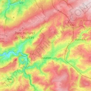
Name: Topografische Karte Stavelot, Höhe, Relief.
Ort: Stavelot, Verviers, Liège, Wallonia, 4970, Belgium (50.33550 5.85104 50.49632 6.03048)
Durchschnittliche Höhe: 431 m
Minimale Höhe: 198 m
Maximale Höhe: 639 m
Stavelot has an oceanic climate influenced by its high elevation and inland position towards a more continental type by Belgian standards. Being located at a lower elevation than neighbouring village Malmedy at the other end of the original layout of the Spa-Francorchamps race track, Stavelot is slightly milder, drier and sunnier than Malmedy year round.
Andere topografische Karten
Klicken Sie auf eine Karte, um ihre Topografie, ihre Höhe und ihr Relief anzuzeigen.
Robertville
Robertville, Waimes, Verviers, Liège, Wallonia, Belgium
Durchschnittliche Höhe: 570 m
Baraque Michel
Belgium > Liège > Verviers > Jalhay
Baraque Michel, Jalhay, Verviers, Liège, Wallonia, 4845, Belgium
Durchschnittliche Höhe: 652 m
Arbrefontaine
Belgium > Liège > Verviers > Arbrefontaine
Arbrefontaine, Lierneux, Verviers, Liège, Wallonia, 4990, Belgium
Durchschnittliche Höhe: 448 m
Francorchamps
Belgium > Liège > Verviers > Stavelot
Francorchamps, Stavelot, Verviers, Liège, Wallonia, 4970, Belgium
Durchschnittliche Höhe: 482 m
Signal de Botrange
Belgium > Liège > Verviers > Robertville
Signal de Botrange, Robertville, Waimes, Verviers, Liège, Wallonia, Belgium
Durchschnittliche Höhe: 658 m
Thimister-Clermont
Thimister-Clermont, Verviers, Liège, Wallonia, 4890, Belgium
Durchschnittliche Höhe: 261 m
Saint Vith
Saint Vith, Verviers, Liège, Wallonia, 4780, Belgium
Durchschnittliche Höhe: 492 m