
Topografische Karte Malmedy
Interaktive Karte
Klicken Sie auf die Karte, um die Höhe anzuzeigen.
Über diese Karte
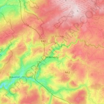
Name: Topografische Karte Malmedy, Höhe, Relief.
Ort: Malmedy, Verviers, Liège, Wallonia, 4960, Belgium (50.35031 5.96961 50.51897 6.11361)
Durchschnittliche Höhe: 489 m
Minimale Höhe: 251 m
Maximale Höhe: 701 m
Malmedy has an oceanic climate with continental influences due to its inland position and higher elevation. Winter can see ice days, strong air frosts and snowfall. Malmedy's high precipitation is commonly affecting the nearby Spa-Francorchamps race track, known for its treacherous weather conditions.
Andere topografische Karten
Klicken Sie auf eine Karte, um ihre Topografie, ihre Höhe und ihr Relief anzuzeigen.
Robertville
Robertville, Waimes, Verviers, Liège, Wallonia, Belgium
Durchschnittliche Höhe: 570 m
Baraque Michel
Belgium > Liège > Verviers > Jalhay
Baraque Michel, Jalhay, Verviers, Liège, Wallonia, 4845, Belgium
Durchschnittliche Höhe: 652 m
Arbrefontaine
Belgium > Liège > Verviers > Arbrefontaine
Arbrefontaine, Lierneux, Verviers, Liège, Wallonia, 4990, Belgium
Durchschnittliche Höhe: 448 m
Francorchamps
Belgium > Liège > Verviers > Stavelot
Francorchamps, Stavelot, Verviers, Liège, Wallonia, 4970, Belgium
Durchschnittliche Höhe: 482 m
Signal de Botrange
Belgium > Liège > Verviers > Robertville
Signal de Botrange, Robertville, Waimes, Verviers, Liège, Wallonia, Belgium
Durchschnittliche Höhe: 658 m
Thimister-Clermont
Thimister-Clermont, Verviers, Liège, Wallonia, 4890, Belgium
Durchschnittliche Höhe: 261 m
Saint Vith
Saint Vith, Verviers, Liège, Wallonia, 4780, Belgium
Durchschnittliche Höhe: 492 m