
Topografische Karte Eupen
Interaktive Karte
Klicken Sie auf die Karte, um die Höhe anzuzeigen.
Über diese Karte
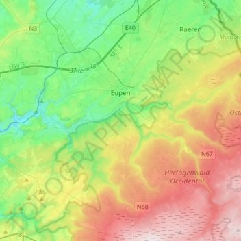
Name: Topografische Karte Eupen, Höhe, Relief.
Ort: Eupen, Verviers, Liège, Wallonia, Belgium (50.54802 6.00060 50.67287 6.27411)
Durchschnittliche Höhe: 368 m
Minimale Höhe: 180 m
Maximale Höhe: 672 m
Eupen has a cool oceanic climate with some continental influences due to it being elevated in comparison to most of Belgium. Eupen is also wetter and cloudier than Liège in the valley to the west, as a result of orographic lift due to the elevation change. As a result of this along with frequent winter frosts, Eupen gets a significant snowfall amount by Belgian standards. It also gets 16.8 ice days on average each year, as in the day staying below 0 °C (32 °F).
Andere topografische Karten
Klicken Sie auf eine Karte, um ihre Topografie, ihre Höhe und ihr Relief anzuzeigen.
Robertville
Robertville, Waimes, Verviers, Liège, Wallonia, Belgium
Durchschnittliche Höhe: 570 m
Baraque Michel
Belgium > Liège > Verviers > Jalhay
Baraque Michel, Jalhay, Verviers, Liège, Wallonia, 4845, Belgium
Durchschnittliche Höhe: 652 m
Arbrefontaine
Belgium > Liège > Verviers > Arbrefontaine
Arbrefontaine, Lierneux, Verviers, Liège, Wallonia, 4990, Belgium
Durchschnittliche Höhe: 448 m
Francorchamps
Belgium > Liège > Verviers > Stavelot
Francorchamps, Stavelot, Verviers, Liège, Wallonia, 4970, Belgium
Durchschnittliche Höhe: 482 m
Signal de Botrange
Belgium > Liège > Verviers > Robertville
Signal de Botrange, Robertville, Waimes, Verviers, Liège, Wallonia, Belgium
Durchschnittliche Höhe: 658 m
Thimister-Clermont
Thimister-Clermont, Verviers, Liège, Wallonia, 4890, Belgium
Durchschnittliche Höhe: 261 m
Saint Vith
Saint Vith, Verviers, Liège, Wallonia, 4780, Belgium
Durchschnittliche Höhe: 492 m