
Topografische Karte Spa
Interaktive Karte
Klicken Sie auf die Karte, um die Höhe anzuzeigen.
Über diese Karte
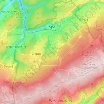
Name: Topografische Karte Spa, Höhe, Relief.
Ort: Spa, Verviers, Liège, Wallonia, 4900, Belgium (50.43362 5.81536 50.51212 5.93175)
Durchschnittliche Höhe: 402 m
Minimale Höhe: 192 m
Maximale Höhe: 580 m
Spa has an oceanic climate that is made more continental by its higher elevation and inland position compared to other Belgian climates at lower level or closer to the sea. Spa has a relatively high precipitation year round, with tricky weather something that the Spa-Francorchamps race track is known for. The elevation also results in cooler summers and frequent winter frost along with snowfall. Spa is quite gloomy year round although averaging both a drier and sunnier climate than nearby locations Stavelot and Malmedy that are also surrounding the race track.
Andere topografische Karten
Klicken Sie auf eine Karte, um ihre Topografie, ihre Höhe und ihr Relief anzuzeigen.
Robertville
Robertville, Waimes, Verviers, Liège, Wallonia, Belgium
Durchschnittliche Höhe: 570 m
Baraque Michel
Belgium > Liège > Verviers > Jalhay
Baraque Michel, Jalhay, Verviers, Liège, Wallonia, 4845, Belgium
Durchschnittliche Höhe: 652 m
Arbrefontaine
Belgium > Liège > Verviers > Arbrefontaine
Arbrefontaine, Lierneux, Verviers, Liège, Wallonia, 4990, Belgium
Durchschnittliche Höhe: 448 m
Francorchamps
Belgium > Liège > Verviers > Stavelot
Francorchamps, Stavelot, Verviers, Liège, Wallonia, 4970, Belgium
Durchschnittliche Höhe: 482 m
Signal de Botrange
Belgium > Liège > Verviers > Robertville
Signal de Botrange, Robertville, Waimes, Verviers, Liège, Wallonia, Belgium
Durchschnittliche Höhe: 658 m
Thimister-Clermont
Thimister-Clermont, Verviers, Liège, Wallonia, 4890, Belgium
Durchschnittliche Höhe: 261 m
Saint Vith
Saint Vith, Verviers, Liège, Wallonia, 4780, Belgium
Durchschnittliche Höhe: 492 m