
Topografische Karte Mojave
Interaktive Karte
Klicken Sie auf die Karte, um die Höhe anzuzeigen.
Über diese Karte
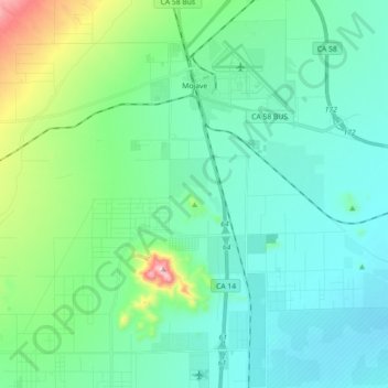
Name: Topografische Karte Mojave, Höhe, Relief.
Ort: Mojave, Kern County, California, United States (34.93736 -118.25786 35.08440 -118.10427)
Durchschnittliche Höhe: 857 m
Minimale Höhe: 760 m
Maximale Höhe: 1.274 m
Mojave (formerly Mohave) is an unincorporated community in Kern County, California, United States. Mojave is located 50 miles (80 km) east of Bakersfield, and 100 miles (161 km) north of Los Angeles, at an elevation of 2,762 feet (842 m). The town is located in the western region of the Mojave Desert, below and east of Oak Creek Pass and the Tehachapi Mountains. Mojave is on the Pacific Crest Trail.
Andere topografische Karten
Klicken Sie auf eine Karte, um ihre Topografie, ihre Höhe und ihr Relief anzuzeigen.
Rosedale
United States > California > Kern County
Rosedale, Kern County, California, United States
Durchschnittliche Höhe: 113 m
Upper Richbar Picnic Area
United States > California > Kern County
Upper Richbar Picnic Area, Kern County, California, United States
Durchschnittliche Höhe: 658 m
Wasco
United States > California > Kern County
Wasco, Kern County, California, United States
Durchschnittliche Höhe: 101 m
Inyokern
United States > California > Kern County
Inyokern, Kern County, California, United States
Durchschnittliche Höhe: 749 m
Baker
United States > California > Kern County > Boron
Baker, Boron, Kern County, California, United States
Durchschnittliche Höhe: 765 m
Rosedale
United States > California > Kern County
Rosedale, Kern County, CAL Fire Contract Counties, California, United States
Durchschnittliche Höhe: 107 m
Ridgecrest
United States > California > Kern County
Ridgecrest, Kern County, California, 93555, United States
Durchschnittliche Höhe: 740 m
Lake Isabella
United States > California > Kern County
Lake Isabella, Kern County, California, United States
Durchschnittliche Höhe: 979 m
Boron
United States > California > Kern County > Boron
Boron, Kern County, California, United States
Durchschnittliche Höhe: 753 m
Tehachapi
United States > California > Kern County
Tehachapi, Kern County, California, 93561, United States
Durchschnittliche Höhe: 1.414 m
Cameron
United States > California > Kern County
Cameron, Kern County, California, United States
Durchschnittliche Höhe: 1.309 m
Rio Bravo
United States > California > Kern County
Rio Bravo, Kern County, California, United States
Durchschnittliche Höhe: 97 m
Bakersfield
United States > California > Kern County
Bakersfield, Kern County, California, United States
Durchschnittliche Höhe: 157 m