
Topografische Karte Rosedale
Interaktive Karte
Klicken Sie auf die Karte, um die Höhe anzuzeigen.
Über diese Karte
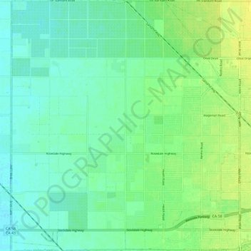
Name: Topografische Karte Rosedale, Höhe, Relief.
Durchschnittliche Höhe: 107 m
Minimale Höhe: 99 m
Maximale Höhe: 118 m
Andere topografische Karten
Klicken Sie auf eine Karte, um ihre Topografie, ihre Höhe und ihr Relief anzuzeigen.
Rosedale
United States > California > Kern County
Rosedale, Kern County, California, United States
Durchschnittliche Höhe: 113 m
Upper Richbar Picnic Area
United States > California > Kern County
Upper Richbar Picnic Area, Kern County, California, United States
Durchschnittliche Höhe: 658 m
Wasco
United States > California > Kern County
Wasco, Kern County, California, United States
Durchschnittliche Höhe: 101 m
Mojave
United States > California > Kern County
Mojave, Kern County, California, United States
Durchschnittliche Höhe: 857 m
Inyokern
United States > California > Kern County
Inyokern, Kern County, California, United States
Durchschnittliche Höhe: 749 m
Baker
United States > California > Kern County > Boron
Baker, Boron, Kern County, California, United States
Durchschnittliche Höhe: 765 m
Ridgecrest
United States > California > Kern County
Ridgecrest, Kern County, California, 93555, United States
Durchschnittliche Höhe: 740 m
Lake Isabella
United States > California > Kern County
Lake Isabella, Kern County, California, United States
Durchschnittliche Höhe: 979 m
Boron
United States > California > Kern County > Boron
Boron, Kern County, California, United States
Durchschnittliche Höhe: 753 m
Tehachapi
United States > California > Kern County
Tehachapi, Kern County, California, 93561, United States
Durchschnittliche Höhe: 1.414 m
Cameron
United States > California > Kern County
Cameron, Kern County, California, United States
Durchschnittliche Höhe: 1.309 m
Rio Bravo
United States > California > Kern County
Rio Bravo, Kern County, California, United States
Durchschnittliche Höhe: 97 m
Bakersfield
United States > California > Kern County
Bakersfield, Kern County, California, United States
Durchschnittliche Höhe: 157 m