
Topografische Karte Tehachapi
Interaktive Karte
Klicken Sie auf die Karte, um die Höhe anzuzeigen.
Über diese Karte
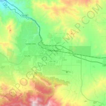
Name: Topografische Karte Tehachapi, Höhe, Relief.
Ort: Tehachapi, Kern County, California, 93561, United States (35.09828 -118.59307 35.15843 -118.39649)
Durchschnittliche Höhe: 1.414 m
Minimale Höhe: 853 m
Maximale Höhe: 2.403 m
Tehachapi (/təˈhætʃəpi/ (listen); Kawaiisu: Tihachipia, meaning "hard climb") is a city in Kern County, California, United States, in the Tehachapi Mountains, at an elevation of 3,970 feet (1,210 m), between the San Joaquin Valley and the Mojave Desert. Tehachapi is 35 miles (56 km) east-southeast of Bakersfield, and 20 miles (32 km) west of Mojave. According to the United States Census Bureau, the city has a total area of 10 square miles (26 km2) and a population of 14,414. The Tehachapi area is known for the nearby Tehachapi Loop (a popular railfan site), the Pacific Crest Trail and for the excellent conditions for the aerial sport of gliding.
Andere topografische Karten
Klicken Sie auf eine Karte, um ihre Topografie, ihre Höhe und ihr Relief anzuzeigen.
Rosedale
United States > California > Kern County
Rosedale, Kern County, California, United States
Durchschnittliche Höhe: 113 m
Upper Richbar Picnic Area
United States > California > Kern County
Upper Richbar Picnic Area, Kern County, California, United States
Durchschnittliche Höhe: 658 m
Wasco
United States > California > Kern County
Wasco, Kern County, California, United States
Durchschnittliche Höhe: 101 m
Mojave
United States > California > Kern County
Mojave, Kern County, California, United States
Durchschnittliche Höhe: 857 m
Inyokern
United States > California > Kern County
Inyokern, Kern County, California, United States
Durchschnittliche Höhe: 749 m
Baker
United States > California > Kern County > Boron
Baker, Boron, Kern County, California, United States
Durchschnittliche Höhe: 765 m
Rosedale
United States > California > Kern County
Rosedale, Kern County, CAL Fire Contract Counties, California, United States
Durchschnittliche Höhe: 107 m
Ridgecrest
United States > California > Kern County
Ridgecrest, Kern County, California, 93555, United States
Durchschnittliche Höhe: 740 m
Lake Isabella
United States > California > Kern County
Lake Isabella, Kern County, California, United States
Durchschnittliche Höhe: 979 m
Boron
United States > California > Kern County > Boron
Boron, Kern County, California, United States
Durchschnittliche Höhe: 753 m
Cameron
United States > California > Kern County
Cameron, Kern County, California, United States
Durchschnittliche Höhe: 1.309 m
Rio Bravo
United States > California > Kern County
Rio Bravo, Kern County, California, United States
Durchschnittliche Höhe: 97 m
Bakersfield
United States > California > Kern County
Bakersfield, Kern County, California, United States
Durchschnittliche Höhe: 157 m