
Topografische Karte Ridgecrest
Interaktive Karte
Klicken Sie auf die Karte, um die Höhe anzuzeigen.
Über diese Karte
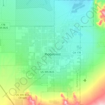
Name: Topografische Karte Ridgecrest, Höhe, Relief.
Ort: Ridgecrest, Kern County, California, 93555, United States (35.56389 -117.70589 35.68079 -117.61640)
Durchschnittliche Höhe: 740 m
Minimale Höhe: 667 m
Maximale Höhe: 1.022 m
Walker Pass (elevation 5,250 ft (1.60 km)) is a mountain pass by Lake Isabella in the southern Sierra Nevada mountains. It is located in northeastern Kern County, approximately 53 mi (85 km) ENE of Bakersfield and 10 mi (16 km) WSW of Ridgecrest. The pass provides a route between the San Joaquin Valley on the west and the Mojave Desert on the east.[citation needed]
Andere topografische Karten
Klicken Sie auf eine Karte, um ihre Topografie, ihre Höhe und ihr Relief anzuzeigen.
Rosedale
United States > California > Kern County
Rosedale, Kern County, California, United States
Durchschnittliche Höhe: 113 m
Upper Richbar Picnic Area
United States > California > Kern County
Upper Richbar Picnic Area, Kern County, California, United States
Durchschnittliche Höhe: 658 m
Wasco
United States > California > Kern County
Wasco, Kern County, California, United States
Durchschnittliche Höhe: 101 m
Mojave
United States > California > Kern County
Mojave, Kern County, California, United States
Durchschnittliche Höhe: 857 m
Inyokern
United States > California > Kern County
Inyokern, Kern County, California, United States
Durchschnittliche Höhe: 749 m
Baker
United States > California > Kern County > Boron
Baker, Boron, Kern County, California, United States
Durchschnittliche Höhe: 765 m
Rosedale
United States > California > Kern County
Rosedale, Kern County, CAL Fire Contract Counties, California, United States
Durchschnittliche Höhe: 107 m
Lake Isabella
United States > California > Kern County
Lake Isabella, Kern County, California, United States
Durchschnittliche Höhe: 979 m
Boron
United States > California > Kern County > Boron
Boron, Kern County, California, United States
Durchschnittliche Höhe: 753 m
Tehachapi
United States > California > Kern County
Tehachapi, Kern County, California, 93561, United States
Durchschnittliche Höhe: 1.414 m
Cameron
United States > California > Kern County
Cameron, Kern County, California, United States
Durchschnittliche Höhe: 1.309 m
Rio Bravo
United States > California > Kern County
Rio Bravo, Kern County, California, United States
Durchschnittliche Höhe: 97 m
Bakersfield
United States > California > Kern County
Bakersfield, Kern County, California, United States
Durchschnittliche Höhe: 157 m