
Topografische Karte Inyokern
Interaktive Karte
Klicken Sie auf die Karte, um die Höhe anzuzeigen.
Über diese Karte
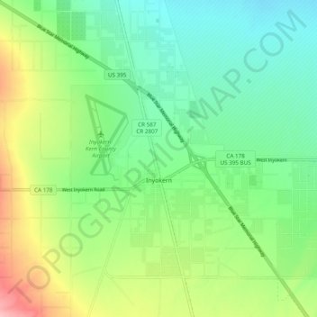
Name: Topografische Karte Inyokern, Höhe, Relief.
Ort: Inyokern, Kern County, California, United States (35.62268 -117.87212 35.68164 -117.77582)
Durchschnittliche Höhe: 749 m
Minimale Höhe: 703 m
Maximale Höhe: 842 m
Inyokern (formerly Siding 16 and Magnolia) is a census-designated place (CDP) in Kern County, California, United States. Its name derives from its location near the border between Inyo and Kern Counties. Inyokern is located 8 miles (13 km) west of Ridgecrest, at an elevation of 2,434 feet (742 m). It is on the western side of the Indian Wells Valley. The population was 988 in the 2020 census, down from 1,099 in the 2010 census. It was a railroad town established along the Southern Pacific railroad's Lone Pine Branch (now removed) and with WWII became site of the Naval Air Weapons Station China Lake.
Andere topografische Karten
Klicken Sie auf eine Karte, um ihre Topografie, ihre Höhe und ihr Relief anzuzeigen.
Rosedale
United States > California > Kern County
Rosedale, Kern County, California, United States
Durchschnittliche Höhe: 113 m
Upper Richbar Picnic Area
United States > California > Kern County
Upper Richbar Picnic Area, Kern County, California, United States
Durchschnittliche Höhe: 658 m
Wasco
United States > California > Kern County
Wasco, Kern County, California, United States
Durchschnittliche Höhe: 101 m
Mojave
United States > California > Kern County
Mojave, Kern County, California, United States
Durchschnittliche Höhe: 857 m
Baker
United States > California > Kern County > Boron
Baker, Boron, Kern County, California, United States
Durchschnittliche Höhe: 765 m
Rosedale
United States > California > Kern County
Rosedale, Kern County, CAL Fire Contract Counties, California, United States
Durchschnittliche Höhe: 107 m
Ridgecrest
United States > California > Kern County
Ridgecrest, Kern County, California, 93555, United States
Durchschnittliche Höhe: 740 m
Lake Isabella
United States > California > Kern County
Lake Isabella, Kern County, California, United States
Durchschnittliche Höhe: 979 m
Boron
United States > California > Kern County > Boron
Boron, Kern County, California, United States
Durchschnittliche Höhe: 753 m
Tehachapi
United States > California > Kern County
Tehachapi, Kern County, California, 93561, United States
Durchschnittliche Höhe: 1.414 m
Cameron
United States > California > Kern County
Cameron, Kern County, California, United States
Durchschnittliche Höhe: 1.309 m
Rio Bravo
United States > California > Kern County
Rio Bravo, Kern County, California, United States
Durchschnittliche Höhe: 97 m
Bakersfield
United States > California > Kern County
Bakersfield, Kern County, California, United States
Durchschnittliche Höhe: 157 m