
Topografische Karte Rondón
Interaktive Karte
Klicken Sie auf die Karte, um die Höhe anzuzeigen.
Über diese Karte
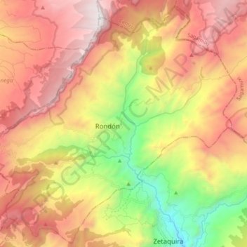
Name: Topografische Karte Rondón, Höhe, Relief.
Ort: Rondón, Lengupá, Boyacá, Colombia (5.28061 -73.28690 5.43859 -73.12249)
Durchschnittliche Höhe: 2.472 m
Minimale Höhe: 1.303 m
Maximale Höhe: 3.542 m
Rondón is a town and municipality in the Márquez Province, part of Boyacá Department, Colombia. The urban centre of Rondón is situated at an altitude of 2,075 metres (6,808 ft) on the Altiplano Cundiboyacense in the Colombian Eastern Ranges of the Andes. It is 61 kilometres (38 mi) away from the departmental capital Tunja. Rondón borders Viracachá and Siachoque in the north, Zetaquirá and Ramiriquí in the south, Pesca in the east and Ramiriquí and Ciénega in the west.
Andere topografische Karten
Klicken Sie auf eine Karte, um ihre Topografie, ihre Höhe und ihr Relief anzuzeigen.
Gachantivá
Gachantivá, Ricaurte, Boyacá, RAP (Especial) Central, Colombia
Durchschnittliche Höhe: 2.365 m
Villa de Leyva
Villa de Leyva, Ricaurte, Boyacá, Colombia
Durchschnittliche Höhe: 2.416 m
La Candelaria
La Candelaria, Ricaurte, Boyacá, Colombia
Durchschnittliche Höhe: 2.354 m
Iguaque
Colombia > Boyacá > Villa de Leyva > VILLA DE LEYVA
Iguaque, VILLA DE LEYVA, Villa de Leyva, Ricaurte, Boyacá, RAP (Especial) Central, 154001, Colombia
Durchschnittliche Höhe: 2.337 m
Villa de Leyva
Colombia > Boyacá > Villa de Leyva
Villa de Leyva, Boyacá, 15401, Colombia
Durchschnittliche Höhe: 2.673 m
Paramo de la Rusia
Paramo de la Rusia, Duitama, Tundama, Boyacá, Colombia
Durchschnittliche Höhe: 3.624 m
Guacamayas
Guacamayas, Gutiérrez, Boyacá, 151220, Colombia
Durchschnittliche Höhe: 2.641 m
Miraflores
Miraflores, Lengupá, Boyacá, RAP (Especial) Central, Colombia
Durchschnittliche Höhe: 1.943 m
Labranzagrande
Labranzagrande, La Libertad, Boyacá, Colombia
Durchschnittliche Höhe: 1.978 m
Cerro El Gaital
Cerro El Gaital, Labranzagrande, Boyacá, Colombia
Durchschnittliche Höhe: 2.178 m