
Topografische Karte Ráquira
Interaktive Karte
Klicken Sie auf die Karte, um die Höhe anzuzeigen.
Über diese Karte
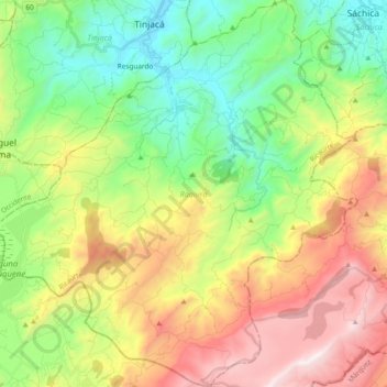
Name: Topografische Karte Ráquira, Höhe, Relief.
Ort: Ráquira, Ricaurte, Boyacá, RAP (Especial) Central, Colombia (5.40347 -73.72398 5.59054 -73.54561)
Durchschnittliche Höhe: 2.677 m
Minimale Höhe: 2.092 m
Maximale Höhe: 3.586 m
Ráquira, is a municipality and town in Boyacá Department, Colombia, part of the subregion of the Ricaurte Province. Ráquira is situated on the Altiplano Cundiboyacense and the urban center at an altitude of 2,150 metres (7,050 ft). It borders Tinjacá and Sutamarchán in the north, Guachetá, Cundinamarca in the south, in the east Sáchica and Samacá and in the west San Miguel de Sema and Lake Fúquene.
Andere topografische Karten
Klicken Sie auf eine Karte, um ihre Topografie, ihre Höhe und ihr Relief anzuzeigen.
Gachantivá
Gachantivá, Ricaurte, Boyacá, RAP (Especial) Central, Colombia
Durchschnittliche Höhe: 2.365 m
Villa de Leyva
Villa de Leyva, Ricaurte, Boyacá, Colombia
Durchschnittliche Höhe: 2.416 m
La Candelaria
La Candelaria, Ricaurte, Boyacá, Colombia
Durchschnittliche Höhe: 2.354 m
Iguaque
Colombia > Boyacá > Villa de Leyva > VILLA DE LEYVA
Iguaque, VILLA DE LEYVA, Villa de Leyva, Ricaurte, Boyacá, RAP (Especial) Central, 154001, Colombia
Durchschnittliche Höhe: 2.337 m
Villa de Leyva
Colombia > Boyacá > Villa de Leyva
Villa de Leyva, Boyacá, 15401, Colombia
Durchschnittliche Höhe: 2.673 m
Paramo de la Rusia
Paramo de la Rusia, Duitama, Tundama, Boyacá, Colombia
Durchschnittliche Höhe: 3.624 m
Guacamayas
Guacamayas, Gutiérrez, Boyacá, 151220, Colombia
Durchschnittliche Höhe: 2.641 m
Miraflores
Miraflores, Lengupá, Boyacá, RAP (Especial) Central, Colombia
Durchschnittliche Höhe: 1.943 m
Labranzagrande
Labranzagrande, La Libertad, Boyacá, Colombia
Durchschnittliche Höhe: 1.978 m
Cerro El Gaital
Cerro El Gaital, Labranzagrande, Boyacá, Colombia
Durchschnittliche Höhe: 2.178 m