
Topografische Karte Gachantivá
Interaktive Karte
Klicken Sie auf die Karte, um die Höhe anzuzeigen.
Über diese Karte
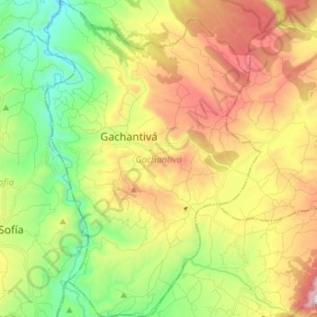
Name: Topografische Karte Gachantivá, Höhe, Relief.
Ort: Gachantivá, Ricaurte, Boyacá, RAP (Especial) Central, Colombia (5.67772 -73.58273 5.80714 -73.49401)
Durchschnittliche Höhe: 2.365 m
Minimale Höhe: 1.846 m
Maximale Höhe: 3.079 m
Gachantivá is a town and municipality in the Ricaurte Province, part of the Colombian department of Boyacá. Gachantivá is located at altitudes ranging from 2,000 metres (6,600 ft) to 3,300 metres (10,800 ft) on the Altiplano Cundiboyacense and borders Villa de Leyva in the south, Santa Sofía in the west, Arcabuco in the east and Moniquirá in the north.
Andere topografische Karten
Klicken Sie auf eine Karte, um ihre Topografie, ihre Höhe und ihr Relief anzuzeigen.
Villa de Leyva
Villa de Leyva, Ricaurte, Boyacá, Colombia
Durchschnittliche Höhe: 2.416 m
La Candelaria
La Candelaria, Ricaurte, Boyacá, Colombia
Durchschnittliche Höhe: 2.354 m
Iguaque
Colombia > Boyacá > Villa de Leyva > VILLA DE LEYVA
Iguaque, VILLA DE LEYVA, Villa de Leyva, Ricaurte, Boyacá, RAP (Especial) Central, 154001, Colombia
Durchschnittliche Höhe: 2.337 m
Villa de Leyva
Colombia > Boyacá > Villa de Leyva
Villa de Leyva, Boyacá, 15401, Colombia
Durchschnittliche Höhe: 2.673 m
Paramo de la Rusia
Paramo de la Rusia, Duitama, Tundama, Boyacá, Colombia
Durchschnittliche Höhe: 3.624 m
Guacamayas
Guacamayas, Gutiérrez, Boyacá, 151220, Colombia
Durchschnittliche Höhe: 2.641 m
Miraflores
Miraflores, Lengupá, Boyacá, RAP (Especial) Central, Colombia
Durchschnittliche Höhe: 1.943 m
Labranzagrande
Labranzagrande, La Libertad, Boyacá, Colombia
Durchschnittliche Höhe: 1.978 m
Cerro El Gaital
Cerro El Gaital, Labranzagrande, Boyacá, Colombia
Durchschnittliche Höhe: 2.178 m