
Topografische Karte Duitama
Interaktive Karte
Klicken Sie auf die Karte, um die Höhe anzuzeigen.
Über diese Karte
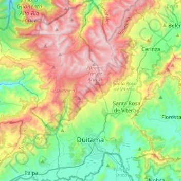
Name: Topografische Karte Duitama, Höhe, Relief.
Ort: Duitama, Tundama, Boyacá, RAP (Especial) Central, Colombia (5.77007 -73.17625 6.02490 -72.99248)
Durchschnittliche Höhe: 3.019 m
Minimale Höhe: 2.374 m
Maximale Höhe: 4.036 m
The elevation of the city is about 2,590 metres (8,500 ft) above sea level and the average temperature is 15 °C.
Andere topografische Karten
Klicken Sie auf eine Karte, um ihre Topografie, ihre Höhe und ihr Relief anzuzeigen.
Gachantivá
Gachantivá, Ricaurte, Boyacá, RAP (Especial) Central, Colombia
Durchschnittliche Höhe: 2.365 m
Villa de Leyva
Villa de Leyva, Ricaurte, Boyacá, Colombia
Durchschnittliche Höhe: 2.416 m
La Candelaria
La Candelaria, Ricaurte, Boyacá, Colombia
Durchschnittliche Höhe: 2.354 m
Iguaque
Colombia > Boyacá > Villa de Leyva > VILLA DE LEYVA
Iguaque, VILLA DE LEYVA, Villa de Leyva, Ricaurte, Boyacá, RAP (Especial) Central, 154001, Colombia
Durchschnittliche Höhe: 2.337 m
Villa de Leyva
Colombia > Boyacá > Villa de Leyva
Villa de Leyva, Boyacá, 15401, Colombia
Durchschnittliche Höhe: 2.673 m
Paramo de la Rusia
Paramo de la Rusia, Duitama, Tundama, Boyacá, Colombia
Durchschnittliche Höhe: 3.624 m
Guacamayas
Guacamayas, Gutiérrez, Boyacá, 151220, Colombia
Durchschnittliche Höhe: 2.641 m
Miraflores
Miraflores, Lengupá, Boyacá, RAP (Especial) Central, Colombia
Durchschnittliche Höhe: 1.943 m
Labranzagrande
Labranzagrande, La Libertad, Boyacá, Colombia
Durchschnittliche Höhe: 1.978 m
Cerro El Gaital
Cerro El Gaital, Labranzagrande, Boyacá, Colombia
Durchschnittliche Höhe: 2.178 m