
Topografische Karte Villa de Leyva
Interaktive Karte
Klicken Sie auf die Karte, um die Höhe anzuzeigen.
Über diese Karte
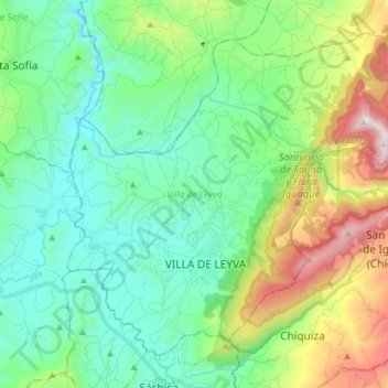
Name: Topografische Karte Villa de Leyva, Höhe, Relief.
Ort: Villa de Leyva, Ricaurte, Boyacá, Colombia (5.59739 -73.57960 5.72629 -73.42343)
Durchschnittliche Höhe: 2.416 m
Minimale Höhe: 1.991 m
Maximale Höhe: 3.575 m
Located away from major trade routes in a high altitude valley of semi-desert terrain, and with no mineral deposits nearby to exploit, the town has undergone little development in the last 400 years. As a consequence, it is one of the few towns in Colombia to have preserved much of its original colonial style and architecture: the streets and large central plaza are still paved with cobblestones, and many buildings date from the sixteenth century. This has resulted in Villa de Leyva becoming one of Colombia's principal tourist attractions, and it was declared a National Monument on December 17, 1954 to preserve its architecture. The town and the surrounding countryside, which contains several sites of interest, are popular weekend destinations for citizens of Bogota, and attract an increasing number of foreign tourists.
Andere topografische Karten
Klicken Sie auf eine Karte, um ihre Topografie, ihre Höhe und ihr Relief anzuzeigen.
Gachantivá
Gachantivá, Ricaurte, Boyacá, RAP (Especial) Central, Colombia
Durchschnittliche Höhe: 2.365 m
La Candelaria
La Candelaria, Ricaurte, Boyacá, Colombia
Durchschnittliche Höhe: 2.354 m
Iguaque
Colombia > Boyacá > Villa de Leyva > VILLA DE LEYVA
Iguaque, VILLA DE LEYVA, Villa de Leyva, Ricaurte, Boyacá, RAP (Especial) Central, 154001, Colombia
Durchschnittliche Höhe: 2.337 m
Villa de Leyva
Colombia > Boyacá > Villa de Leyva
Villa de Leyva, Boyacá, 15401, Colombia
Durchschnittliche Höhe: 2.673 m
Paramo de la Rusia
Paramo de la Rusia, Duitama, Tundama, Boyacá, Colombia
Durchschnittliche Höhe: 3.624 m
Guacamayas
Guacamayas, Gutiérrez, Boyacá, 151220, Colombia
Durchschnittliche Höhe: 2.641 m
Miraflores
Miraflores, Lengupá, Boyacá, RAP (Especial) Central, Colombia
Durchschnittliche Höhe: 1.943 m
Labranzagrande
Labranzagrande, La Libertad, Boyacá, Colombia
Durchschnittliche Höhe: 1.978 m
Cerro El Gaital
Cerro El Gaital, Labranzagrande, Boyacá, Colombia
Durchschnittliche Höhe: 2.178 m