
Topografische Karte Glacier National Park
Interaktive Karte
Klicken Sie auf die Karte, um die Höhe anzuzeigen.
Über diese Karte
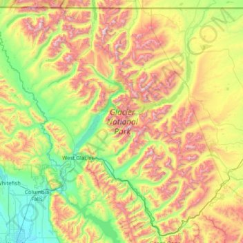
Name: Topografische Karte Glacier National Park, Höhe, Relief.
Ort: Glacier National Park, Montana, 59916, United States (48.23370 -114.47550 49.00111 -113.24162)
Durchschnittliche Höhe: 1.594 m
Minimale Höhe: 888 m
Maximale Höhe: 3.051 m
One of the most dramatic evidences of this overthrust is visible in the form of Chief Mountain, an isolated peak on the edge of the eastern boundary of the park rising 2,500 feet (800 m) above the Great Plains. There are six mountains in the park over 10,000 feet (3,000 m) in elevation, with Mount Cleveland at 10,466 feet (3,190 m) being the tallest. Appropriately named Triple Divide Peak sends waters towards the Pacific Ocean, Hudson Bay, and Gulf of Mexico watersheds. This peak can effectively be considered to be the apex of the North American continent, although the mountain is only 8,020 feet (2,444 m) above sea level.
Andere topografische Karten
Klicken Sie auf eine Karte, um ihre Topografie, ihre Höhe und ihr Relief anzuzeigen.
Bozeman
United States > Montana > Gallatin County
Bozeman, Gallatin County, Montana, United States
Durchschnittliche Höhe: 1.495 m
Estes Lake
United States > Montana > Lake County
Estes Lake, Lake County, Montana, United States
Durchschnittliche Höhe: 1.068 m
Darby
United States > Montana > Ravalli County
Darby, Ravalli County, Montana, United States
Durchschnittliche Höhe: 1.210 m
Lost Horse Mountain
United States > Montana > Powell County
Lost Horse Mountain, Powell County, Montana, United States
Durchschnittliche Höhe: 1.795 m
Bancroft Pond Nature Area
United States > Montana > Missoula County > Missoula
Bancroft Pond Nature Area, Lewis & Clark, Missoula, Missoula County, Montana, United States
Durchschnittliche Höhe: 1.005 m
Whitefish
United States > Montana > Flathead County
Whitefish, Flathead County, Montana, 59937, United States
Durchschnittliche Höhe: 1.075 m
Gold Butte
United States > Montana > Rosebud County
Gold Butte, Rosebud County, Montana, United States
Durchschnittliche Höhe: 899 m
Missoula
United States > Montana > Missoula County
Missoula, Missoula County, Montana, United States
Durchschnittliche Höhe: 1.173 m
Thompson Falls
United States > Montana > Sanders County
Thompson Falls, Sanders County, Montana, 59873, United States
Durchschnittliche Höhe: 782 m
Big Sky Mobile Home Park
United States > Montana > Ravalli County
Big Sky Mobile Home Park, Ravalli County, Montana, 59840, United States
Durchschnittliche Höhe: 1.116 m
Crow Agency
United States > Montana > Big Horn County
Crow Agency, Big Horn County, Montana, 59022, United States
Durchschnittliche Höhe: 959 m
Morgan
United States > Montana > Phillips County
Morgan, Phillips County, Montana, United States
Durchschnittliche Höhe: 854 m
Toad Lake
United States > Montana > Glacier County
Toad Lake, Glacier County, Montana, United States
Durchschnittliche Höhe: 1.486 m
Mount Wam
United States > Montana > Lincoln County
Mount Wam, Lincoln County, Montana, United States
Durchschnittliche Höhe: 1.944 m
Miles City
United States > Montana > Custer County
Miles City, Custer County, Montana, United States
Durchschnittliche Höhe: 724 m
St. Marie
United States > Montana > Valley County
St. Marie, Valley County, Montana, 59231, United States
Durchschnittliche Höhe: 811 m
Polaris
United States > Montana > Beaverhead County
Polaris, Beaverhead County, Montana, United States
Durchschnittliche Höhe: 2.016 m
Jackson
United States > Montana > Beaverhead County
Jackson, Beaverhead County, Montana, 59736, United States
Durchschnittliche Höhe: 1.995 m
Belgrade
United States > Montana > Gallatin County
Belgrade, Gallatin County, Montana, 59714, United States
Durchschnittliche Höhe: 1.355 m
Flathead Lake
United States > Montana > Lake County
Flathead Lake, Lake County, Montana, United States
Durchschnittliche Höhe: 1.168 m
Garfield County
Garfield County, Montana, United States
Durchschnittliche Höhe: 827 m
Roosevelt County
Roosevelt County, Montana, United States
Durchschnittliche Höhe: 703 m
Poplar River
Poplar River, Montana, United States
Durchschnittliche Höhe: 773 m
Monida
United States > Montana > Beaverhead County
Monida, Beaverhead County, Montana, United States
Durchschnittliche Höhe: 2.111 m
Sky Pilot
United States > Montana > Ravalli County
Sky Pilot, Ravalli County, Montana, United States
Durchschnittliche Höhe: 2.281 m
Chrome Island
United States > Montana > Wibaux County
Chrome Island, Wibaux County, Montana, United States
Durchschnittliche Höhe: 730 m
Red Lodge
United States > Montana > Carbon County > Red Lodge
Red Lodge, Carbon County, Montana, 59068, United States
Durchschnittliche Höhe: 1.720 m
Lightning Lake
United States > Montana > Gallatin County
Lightning Lake, Gallatin County, Montana, United States
Durchschnittliche Höhe: 2.690 m
Larch Hill
United States > Montana > Flathead County
Larch Hill, Flathead County, Montana, United States
Durchschnittliche Höhe: 2.245 m
Silver Bow
United States > Montana > Silver Bow
Silver Bow, Montana, United States
Durchschnittliche Höhe: 1.924 m
Big Sky
United States > Montana > Gallatin County
Big Sky, Gallatin County, Montana, United States
Durchschnittliche Höhe: 2.435 m
Bozeman
United States > Montana > Gallatin County > Bozeman
Bozeman, Gallatin County, Montana, 59715, United States
Durchschnittliche Höhe: 1.679 m
Dillon
United States > Montana > Beaverhead County
Dillon, Beaverhead County, Montana, United States
Durchschnittliche Höhe: 1.562 m
Lincoln County
Lincoln County, Montana, United States
Durchschnittliche Höhe: 1.283 m
Woods Bay
United States > Montana > Lake County > Orchard Hills Mobile Home Park
Woods Bay, Orchard Hills Mobile Home Park, Lake County, Montana, United States
Durchschnittliche Höhe: 944 m
Sunrise Trailer Court
United States > Montana > Pondera County > Conrad > Sunrise Trailer Court
Sunrise Trailer Court, Conrad, Pondera County, Montana, United States
Durchschnittliche Höhe: 1.071 m
Huston
United States > Montana > Missoula County
Huston, Missoula County, Montana, United States
Durchschnittliche Höhe: 2.321 m
Whitehall
United States > Montana > Jefferson County > Whitehall
Whitehall, Jefferson County, Montana, United States
Durchschnittliche Höhe: 1.336 m
Sidney
United States > Montana > Sidney
Sidney, Richland County, Montana, 59270, United States
Durchschnittliche Höhe: 593 m
Waterton River
United States > Montana > Glacier County
Waterton River, Glacier County, Montana, United States
Durchschnittliche Höhe: 1.700 m
Springhill
United States > Montana > Gallatin County > Springhill
Springhill, Gallatin County, Montana, United States
Durchschnittliche Höhe: 1.491 m
Old Woman Lake
Old Woman Lake, Blaine County, Montana, United States
Durchschnittliche Höhe: 787 m
Pony
United States > Montana > Madison County
Pony, Madison County, Montana, 59747, United States
Durchschnittliche Höhe: 1.766 m
Poplar River
United States > Montana > Roosevelt County
Poplar River, Roosevelt County, Montana, 59255, United States
Durchschnittliche Höhe: 622 m
Harrison Mill
United States > Montana > Harrison Mill
Harrison Mill, Madison County, Montana, 59735, United States
Durchschnittliche Höhe: 1.487 m
Lewis and Clark County
Lewis and Clark County, Montana, United States
Durchschnittliche Höhe: 1.554 m
Jefferson County
Jefferson County, Montana, United States
Durchschnittliche Höhe: 1.750 m
Wheatland County
Wheatland County, Montana, United States
Durchschnittliche Höhe: 1.519 m
Yellowstone County
Yellowstone County, Montana, United States
Durchschnittliche Höhe: 1.067 m
Flathead County
Flathead County, Montana, United States
Durchschnittliche Höhe: 1.497 m